
Haz una donación
Mapa topográfico Chester County
Haga clic en el mapa para ver la altitud.
Haz una donación
Acerca de este mapa
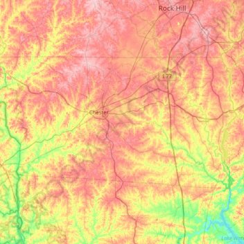
Nombre: Mapa topográfico Chester County, altitud, relieve.
Lugar: Chester County, South Carolina, United States (34.54358 -81.48863 34.82234 -80.86004)
Altitud media: 151 m
Altitud mínima: 67 m
Altitud máxima: 226 m
Haz una donación
Otros mapas topográficos
Haga clic en un mapa para ver su topografía, su altitud y su relieve.
Sullivans Island
United States > South Carolina > Charleston County > Sullivan"s Island > Sullivans Island
Altitud media: 1 m
Haz una donación
Haz una donación
Sassafras Mountain
United States > South Carolina
The Pisgah Quadrangle topographical map, revised 1904–1905, shows the long abandoned Sassafras Gap Road to be the preferred route through to Rosman, N.C. and Brevard, N.C. at the end of the 19th Century and that the existing Highway 178 was then a secondary road. This abandoned road is a short distance from…
Altitud media: 895 m
Haz una donación
Haz una donación
Haz una donación
Haz una donación
Deerwood
United States > South Carolina > Aiken County > Aiken > Verandas on the Green
Altitud media: 136 m
Haz una donación
Haz una donación
Haz una donación
Charleston Farms
United States > South Carolina > Charleston County > North Charleston
Altitud media: 8 m
Haz una donación
Elmwood Park Historic District
United States > South Carolina > Richland County > Columbia
Altitud media: 76 m
Country Club Heights
United States > South Carolina > Marlboro County > Bennettsville
Altitud media: 50 m
Haz una donación
Haz una donación
Haz una donación
Haz una donación
Peachtree Rock Heritage Preserve
United States > South Carolina > Lexington County
Altitud media: 148 m
Haz una donación
Haz una donación
Georgia Street Park
United States > South Carolina > Greenville County > Fountain Inn
Altitud media: 257 m
Andrew Jackson State Park
United States > South Carolina > Lancaster County > Lancaster
Altitud media: 165 m
Haz una donación
Haz una donación
Hampton Forest Apartments
United States > South Carolina > Greenville County > Wade Hampton
Altitud media: 306 m
Haz una donación
Haz una donación
Haz una donación
Seabrook Island
United States > South Carolina > Charleston County > Seabrook Island
Altitud media: 2 m
Haz una donación
Sullivan's Island
United States > South Carolina > Charleston County > Sullivan's Island
Altitud media: 2 m
Haz una donación
Hilton Head Lakes North
United States > South Carolina > Jasper County > Hardeeville
Altitud media: 3 m
Haz una donación
Haz una donación