
Haz una donación
Mapa topográfico Sassafras Mountain
Haga clic en el mapa para ver la altitud.
Haz una donación
Sassafras Mountain
The Pisgah Quadrangle topographical map, revised 1904–1905, shows the long abandoned Sassafras Gap Road to be the preferred route through to Rosman, N.C. and Brevard, N.C. at the end of the 19th Century and that the existing Highway 178 was then a secondary road. This abandoned road is a short distance from the summit and is crossed by the hiking trail to Caesars Head from Sassafras summit. Most people crossing this old roadbed in Sassafras Gap don't recognize it as a road, but it is easily recognized because of the short section of steps going down into the roadbed, and a similar section of short steps on the opposite side of the roadbed going up and the trail then continuing steeply up toward Caesars Head. A short hike South down the old Sassafras Gap Road will take you to Hickory Head Spring, the headwater of the South Saluda River. Hickory Head Spring is shown as a feature on the Mill's Atlas, 1825, Greenville District, South Carolina.
Haz una donación
Acerca de este mapa
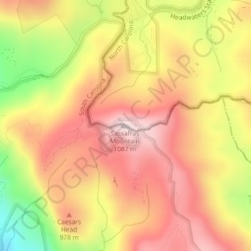
Nombre: Mapa topográfico Sassafras Mountain, altitud, relieve.
Altitud media: 895 m
Altitud mínima: 624 m
Altitud máxima: 1.071 m
Haz una donación
Otros mapas topográficos
Haga clic en un mapa para ver su topografía, su altitud y su relieve.
Blacksburg
United States > South Carolina > Cherokee County
Whitaker Mountain is partially in the northern corner of the town, with a summit elevation outside the town limits of approximately 1,169 ft (356 m).
Altitud media: 228 m
Haz una donación
Paris Mountain State Park
United States > South Carolina > Greenville County
Paris Mountain lies in the Piedmont region of the United States. The mountain is a monadnock, a mountain that stands alone in an area. The word "monadnock" comes from Mount Monadnock in New Hampshire. The elevation of Paris Mountain exceeds 2,000 feet (609.6 m). The Piedmont region where Paris Mountain is…
Altitud media: 377 m
Haz una donación
Haz una donación
Haz una donación
Haz una donación
Lake Secession
United States > South Carolina > Abbeville County
Secession Lake is a reservoir on the Rocky River, a tributary of the Savannah River. The spillway elevation is 548 feet (167 m) above sea level. The reservoir extends north into Anderson County, but the CDP consists only of residences built around the lake within Abbeville County. The Antreville CDP borders…
Altitud media: 188 m
Haz una donación
Lyman Lake
United States > South Carolina > Spartanburg County > Cove Subdivision
Altitud media: 278 m
Haz una donación
Haz una donación
Lesslie
United States > South Carolina > York County
Lesslie has a total area of 6.0 square miles (16 km2), and an elevation of 701 feet (214 m).
Altitud media: 193 m
Haz una donación
Homeland Park
United States > South Carolina > Anderson County > Varennes Heights
Altitud media: 234 m
Haz una donación
Haz una donación
Peachtree Rock Heritage Preserve
United States > South Carolina > Lexington County
Altitud media: 148 m
Haz una donación
Haz una donación
Georgia Street Park
United States > South Carolina > Greenville County > Fountain Inn
Altitud media: 257 m
Haz una donación
Andrew Jackson State Park
United States > South Carolina > Lancaster County > Lancaster
Altitud media: 165 m
Haz una donación
Haz una donación
Jenkins Island
United States > South Carolina > Beaufort County > Hilton Head Island
Altitud media: 1 m
Haz una donación
Haz una donación
Haz una donación
Lake Hartwell State Park
United States > South Carolina > Oconee County > Fairplay Shores
Altitud media: 213 m
Haz una donación
Haz una donación
Chestnut Ridge Heritage Preserve
United States > South Carolina > Greenville County
Altitud media: 391 m
Kings Mountain National Military Park
United States > South Carolina > York County > Blacksburg
Altitud media: 241 m
Haz una donación
Haz una donación
Haz una donación
Haz una donación