
Gracias por apoyar a este sitio ❤️
Haz una donación
Haz una donación
Mapa topográfico East Gaffney
Haga clic en el mapa para ver la altitud.
Gracias por apoyar a este sitio ❤️
Haz una donación
Haz una donación
Acerca de este mapa
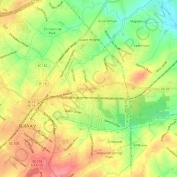
Nombre: Mapa topográfico East Gaffney, altitud, relieve.
Altitud media: 223 m
Altitud mínima: 176 m
Altitud máxima: 263 m
Gracias por apoyar a este sitio ❤️
Haz una donación
Haz una donación
Otros mapas topográficos
Haga clic en un mapa para ver su topografía, su altitud y su relieve.
Blacksburg
United States > South Carolina > Cherokee County
Whitaker Mountain is partially in the northern corner of the town, with a summit elevation outside the town limits of approximately 1,169 ft (356 m).
Altitud media: 228 m