
Mapa topográfico Luisenthal
Mapa interactivo
Haga clic en el mapa para ver la altitud.
Acerca de este mapa
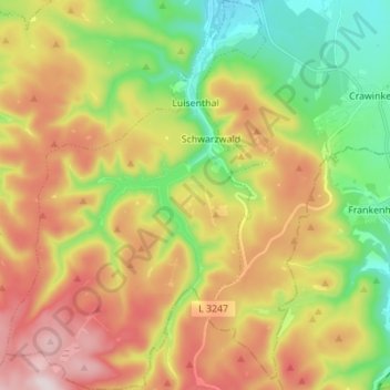
Nombre: Mapa topográfico Luisenthal, altitud, relieve.
Lugar: Luisenthal, Ohrdruf, Landkreis Gotha, Thüringen, Deutschland (50.71548 10.65655 50.80288 10.75162)
Altitud media: 624 m
Altitud mínima: 408 m
Altitud máxima: 890 m
Luisenthal liegt als Straßendorf auf einer Höhe von etwa 420 bis 465 Metern langgezogen im Talgrund der Ohra im Thüringer Wald, oberhalb des Ortsteils Schwarzwald befindet sich die Ohra-Talsperre. Nach Süden reicht die Gemarkung Schwarzwald bis dicht an den Rennsteig.
Otros mapas topográficos
Haga clic en un mapa para ver su topografía, su altitud y su relieve.
Gotha
Deutschland > Thüringen > Landkreis Gotha
Gotha, Landkreis Gotha, Thüringen, Deutschland
Altitud media: 320 m
Ingersleben
Deutschland > Thüringen > Landkreis Gotha
Ingersleben, Nesse-Apfelstädt, Landkreis Gotha, Thüringen, 99192, Deutschland
Altitud media: 265 m
Finsterbergen
Deutschland > Thüringen > Landkreis Gotha > Friedrichroda
Finsterbergen, Friedrichroda, Landkreis Gotha, Thüringen, 99894, Deutschland
Altitud media: 505 m
Friedrichroda
Deutschland > Thüringen > Landkreis Gotha
Friedrichroda, Landkreis Gotha, Thüringen, 99894, Deutschland
Altitud media: 495 m
Laucha
Deutschland > Thüringen > Landkreis Gotha
Laucha, Hörsel, Landkreis Gotha, Thüringen, Deutschland
Altitud media: 313 m
Georgenthal
Deutschland > Thüringen > Landkreis Gotha
Georgenthal, Landkreis Gotha, Thüringen, 99887, Deutschland
Altitud media: 404 m
Hörselgau
Deutschland > Thüringen > Landkreis Gotha
Hörselgau, Hörsel, Landkreis Gotha, Thüringen, 99880, Deutschland
Altitud media: 311 m
Bienstädt
Deutschland > Thüringen > Landkreis Gotha
Bienstädt, Nesseaue, Landkreis Gotha, Thüringen, Deutschland
Altitud media: 344 m
Sonneborn
Deutschland > Thüringen > Landkreis Gotha
Sonneborn, Nessetal, Landkreis Gotha, Thüringen, Deutschland
Altitud media: 295 m
Neufrankenroda
Deutschland > Thüringen > Landkreis Gotha > Hörsel
Neufrankenroda, Hörsel, Landkreis Gotha, Thüringen, Deutschland
Altitud media: 330 m
Döllstädt
Deutschland > Thüringen > Landkreis Gotha
Döllstädt, Fahner Höhe, Landkreis Gotha, Thüringen, Deutschland
Altitud media: 222 m
Fahner Höhe
Deutschland > Thüringen > Landkreis Gotha
Fahner Höhe, Landkreis Gotha, Thüringen, Deutschland
Altitud media: 244 m
Hochheim
Deutschland > Thüringen > Landkreis Gotha > Nessetal
Hochheim, Nessetal, Landkreis Gotha, Thüringen, Deutschland
Altitud media: 299 m
Molschleben
Deutschland > Thüringen > Landkreis Gotha
Molschleben, Nesseaue, Landkreis Gotha, Thüringen, Deutschland
Altitud media: 317 m
Cobstädt
Deutschland > Thüringen > Landkreis Gotha
Cobstädt, Cobstädt/Grabsleben/Großrettbach, Drei Gleichen, Landkreis Gotha, Thüringen, Deutschland
Altitud media: 285 m
Ohrdruf
Deutschland > Thüringen > Landkreis Gotha
Ohrdruf, Landkreis Gotha, Thüringen, 99885, Deutschland
Altitud media: 518 m
Goldbach
Deutschland > Thüringen > Landkreis Gotha > Nessetal
Goldbach, Nessetal, Landkreis Gotha, Thüringen, Deutschland
Altitud media: 300 m
Nessetal
Deutschland > Thüringen > Landkreis Gotha
Nessetal, Landkreis Gotha, Thüringen, Deutschland
Altitud media: 297 m
Crawinkel
Deutschland > Thüringen > Landkreis Gotha > Ohrdruf
Crawinkel, Ohrdruf, Landkreis Gotha, Thüringen, Deutschland
Altitud media: 536 m
Waltershausen
Deutschland > Thüringen > Landkreis Gotha
Waltershausen, Landkreis Gotha, Thüringen, Deutschland
Altitud media: 426 m
Ballstädt
Deutschland > Thüringen > Landkreis Gotha > Nessetal
Ballstädt, Nessetal, Landkreis Gotha, Thüringen, Deutschland
Altitud media: 287 m
Wölfis
Deutschland > Thüringen > Landkreis Gotha > Ohrdruf
Wölfis, Ohrdruf, Landkreis Gotha, Thüringen, 99885, Deutschland
Altitud media: 443 m
Siebleben
Deutschland > Thüringen > Landkreis Gotha > Gotha
Siebleben, Gotha, Landkreis Gotha, Thüringen, 99867, Deutschland
Altitud media: 297 m
Nottleben
Deutschland > Thüringen > Landkreis Gotha
Nottleben, Nesseaue, Landkreis Gotha, Thüringen, Deutschland
Altitud media: 298 m
Wangenheim
Deutschland > Thüringen > Landkreis Gotha > Nessetal
Wangenheim, Nessetal, Landkreis Gotha, Thüringen, Deutschland
Altitud media: 299 m
Röhnberg
Deutschland > Thüringen > Landkreis Gotha
Röhnberg, Drei Gleichen, Landkreis Gotha, Thüringen, Deutschland
Altitud media: 300 m
Uelleben
Deutschland > Thüringen > Landkreis Gotha > Gotha
Uelleben, Gotha, Landkreis Gotha, Thüringen, 99867, Deutschland
Altitud media: 329 m
Tambach-Dietharz
Deutschland > Thüringen > Landkreis Gotha
Tambach-Dietharz, Landkreis Gotha, Thüringen, 99897, Deutschland
Altitud media: 663 m
Langenhain
Deutschland > Thüringen > Landkreis Gotha > Waltershausen > Langenhain
Langenhain, Waltershausen, Landkreis Gotha, Thüringen, 99880, Deutschland
Altitud media: 368 m
Wipperoda
Deutschland > Thüringen > Landkreis Gotha > Georgenthal > Wipperoda
Wipperoda, Georgenthal, Landkreis Gotha, Thüringen, 99887, Deutschland
Altitud media: 357 m
Georgenthal
Deutschland > Thüringen > Landkreis Gotha > Georgenthal
Georgenthal, Landkreis Gotha, Thüringen, Deutschland
Altitud media: 523 m
Schönau vor dem Walde
Deutschland > Thüringen > Landkreis Gotha > Georgenthal > Schönau vor dem Walde
Schönau vor dem Walde, Georgenthal, Landkreis Gotha, Thüringen, 99887, Deutschland
Altitud media: 387 m
Kallenberg
Deutschland > Thüringen > Landkreis Gotha
Kallenberg, Drei Gleichen, Landkreis Gotha, Thüringen, Deutschland
Altitud media: 284 m
Drei Gleichen
Deutschland > Thüringen > Landkreis Gotha
Drei Gleichen, Landkreis Gotha, Thüringen, 99869, Deutschland
Altitud media: 308 m
Mühlberg
Deutschland > Thüringen > Landkreis Gotha
Mühlberg, Drei Gleichen, Landkreis Gotha, Thüringen, 99869, Deutschland
Altitud media: 323 m
Seebergen
Deutschland > Thüringen > Landkreis Gotha
Seebergen, Drei Gleichen, Landkreis Gotha, Thüringen, 99869, Deutschland
Altitud media: 297 m
Bad Tabarz
Deutschland > Thüringen > Landkreis Gotha
Bad Tabarz, Landkreis Gotha, Thüringen, 99891, Deutschland
Altitud media: 541 m
Hohe Wurzel
Deutschland > Thüringen > Landkreis Gotha > Waltershausen
Hohe Wurzel, Waltershausen, Landkreis Gotha, Thüringen, 99880, Deutschland
Altitud media: 417 m
Gräfentonna
Deutschland > Thüringen > Landkreis Gotha
Gräfentonna, Tonna, Fahner Höhe, Landkreis Gotha, Thüringen, 99958, Deutschland
Altitud media: 194 m
Schwabhausen
Deutschland > Thüringen > Landkreis Gotha
Schwabhausen, Drei Gleichen, Landkreis Gotha, Thüringen, Deutschland
Altitud media: 352 m
Wandersleben
Deutschland > Thüringen > Landkreis Gotha
Wandersleben, Drei Gleichen, Landkreis Gotha, Thüringen, 99869, Deutschland
Altitud media: 280 m
Großer Inselsberg
Deutschland > Thüringen > Landkreis Gotha > Bad Tabarz
Großer Inselsberg, Bad Tabarz, Landkreis Gotha, Thüringen, 98596, Deutschland
Altitud media: 709 m