
Haz una donación
Mapa topográfico Kallenberg
Haga clic en el mapa para ver la altitud.
Haz una donación
Acerca de este mapa
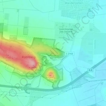
Nombre: Mapa topográfico Kallenberg, altitud, relieve.
Altitud media: 284 m
Altitud mínima: 253 m
Altitud máxima: 391 m
Haz una donación
Otros mapas topográficos
Haga clic en un mapa para ver su topografía, su altitud y su relieve.
Ohrdruf
Deutschland > Thüringen > Landkreis Gotha
Die Kirche St. Michaelis war bis Februar 1945 die evangelische Stadtkirche von Ohrdruf, deren Anfänge bis ins 8. Jahrhundert zurückreichen. Sie wurde bei einem Luftangriff am 6. Februar 1945 bis auf den Turm zerstört. Heute ist von ihr nur noch dieser Kirchturm erhalten. Er wurde nach der Wende bis 1999…
Altitud media: 518 m
Friedrichroda
Deutschland > Thüringen > Landkreis Gotha
Am 6. Februar 1945 erlitt Friedrichroda einen amerikanischen Luftangriff mit Abwurf von „120.500 Pfund Bomben und 10 Flugblatt-Einheiten“. 135 Tote (darunter 29 Kinder), 74 total zerstörte und 350 beschädigte Häuser waren die Folge. Die Opfer wurden in einem Gemeinschaftsgrab auf dem Friedhof…
Altitud media: 495 m
Gotha
Deutschland > Thüringen > Landkreis Gotha
Das Stadtgebiet erstreckt sich zwischen der Trügleber Höhe, dem Boxberg und dem Kleinen Seeberg auf einer Fläche von über 6900 ha. Der Krahnberg im Nordwesten bildet mit 431,3 m ü. NN den höchsten Punkt im Stadtgebiet. Der tiefste Punkt befindet sich mit 269,4 m ü. NN im Heutal.
Altitud media: 320 m
Haz una donación
Waltershausen
Deutschland > Thüringen > Landkreis Gotha
Am 6. Februar 1945 erlebte Waltershausen – wie am selben Tag mehrere Städte in der Region – einen US-amerikanischen Bombenangriff. 12 B-17G „Flying Fortress“ warfen um die Mittagszeit aus 8.000 m Höhe 30 Tonnen (120 Stück) Bomben. 21 Gebäude wurden zerstört und 20 Tote gezählt.
Altitud media: 426 m
Burg Gleichen
Deutschland > Thüringen > Landkreis Gotha
Die Höhenburg entstand auf einem kegelförmigen Berg (369,6 m ü. NN), sie ragt etwa 100 Meter über die umgebende, von den Flüssen Gera und Apfelstädt modellierte Landschaft empor. Der Burgberg und die westlich folgenden Erhebungen Kaffberg (399 m ü. NN), Röhnberg (382,2 m ü. NN) sowie der nordwestlich…
Altitud media: 287 m
Dachwig
Deutschland > Thüringen > Landkreis Gotha
Dachwig ist eine Gemeinde im thüringischen Landkreis Gotha und Mitglied der Verwaltungsgemeinschaft Fahner Höhe.
Altitud media: 189 m
Haz una donación
Tambach-Dietharz
Deutschland > Thüringen > Landkreis Gotha
Tambach-Dietharz liegt an der Nordabdachung des Thüringer Waldes westlich von Ohrdruf. Die Stadt liegt auf einer höheren Rodungsinsel an der Landesstraße 1028, die hinab in das nördliche Vorland des Thüringer Waldes führt.
Altitud media: 663 m
Haz una donación
Haz una donación
Ballstädt
Deutschland > Thüringen > Landkreis Gotha > Nessetal
Ballstädt liegt im Thüringer Becken, an den westlichen Ausläufern der Fahner Höhen, etwa in der Mitte zwischen Gotha, Erfurt und Bad Langensalza. Die Nachbarorte sind Hausen und Pfullendorf im Süden, Westhausen im Südwesten, Eschenbergen im Südosten, Aschara im Nordwesten und Burgtonna im Norden.
Altitud media: 287 m
Haz una donación
Crawinkel
Deutschland > Thüringen > Landkreis Gotha > Ohrdruf
Zu Crawinkel bemerkt Galletti in seiner topographisch-historischen Beschreibung des Gothaer Herzogtums von 1780.
Altitud media: 536 m
Fahner Höhe
Deutschland > Thüringen > Landkreis Gotha
In der Verwaltungsgemeinschaft Fahner Höhe im thüringischen Landkreis Gotha haben sich die Gemeinden Dachwig, Döllstädt, Gierstädt, Großfahner und Tonna zusammengeschlossen. Sitz der Verwaltungsgemeinschaft ist Tonna. Der Name bezieht sich auf die Fahner Höhe.
Altitud media: 244 m
Haz una donación
Molschleben
Deutschland > Thüringen > Landkreis Gotha
Molschleben liegt am Südwesthang der Fahner Höhe. Die nächstliegenden Dörfer und Gemeinden sind Eschenbergen (N), Bienstädt (NO), Tröchtelborn (SO), Friemar (S) und Bufleben (W). Das umgebende Land ist ausschließlich landwirtschaftlich genutzt. Am südwestlichen Ortsrand entlang fließt die Nesse. Im…
Altitud media: 317 m
Hochheim
Deutschland > Thüringen > Landkreis Gotha > Nessetal
Im nördlichen Teil des Gothaer Landes, im Städte-Dreieck zwischen Gotha, Bad Langensalza und Erfurt, befindet sich im fruchtbaren Nessetal die Gemeinde Hochheim. Der Ort liegt nahe der Bundesstraße 247 an den südlichen Ausläufern des Hainichs in etwa 269 bis 290 m Höhe ü. NN. Die Nachbarorte sind im…
Altitud media: 299 m
Döllstädt
Deutschland > Thüringen > Landkreis Gotha
Döllstädt ist eine Gemeinde im thüringischen Landkreis Gotha. Sie gehört der Verwaltungsgemeinschaft Fahner Höhe an.
Altitud media: 222 m
Neufrankenroda
Deutschland > Thüringen > Landkreis Gotha > Hörsel
Neufrankenroda liegt am Fuße des 390 m ü. NN hohen Haynberges, einer langgestreckten flachen Anhöhe, der das Tal der Hörsel (etwa 276 m ü. NN) vom tiefer gelegenen Tal der Nesse (etwa 254 m ü. NN) trennt. Der Ort befindet sich auf einer Höhe von etwa 345 m ü. NN, westlich der Kreisstadt Gotha und etwa…
Altitud media: 330 m
Haz una donación
Bienstädt
Deutschland > Thüringen > Landkreis Gotha
Bienstädt liegt etwa 13 Kilometer (Luftlinie) nordwestlich der thüringischen Landeshauptstadt Erfurt am Südostrand der Fahner Höhe. Höchste Erhebung ist ein Grenzpunkt auf dem Kamm der Fahner Höhe (405,3 m ü. NN), gefolgt vom Bienstädter Berg (385,2 m ü. NN) mit der dort befindlichen Bienstädter…
Altitud media: 344 m
Haz una donación
Haz una donación
Westhausen
Deutschland > Thüringen > Landkreis Gotha
Westhausen liegt an der Bundesstraße 247 zwischen Gotha und Bad Langensalza im Tal der Nesse. Nördlich von Westhausen liegt die Ballstädter Höhe (309 Meter Meereshöhe).
Altitud media: 287 m
Luisenthal
Deutschland > Thüringen > Landkreis Gotha
Luisenthal liegt als Straßendorf auf einer Höhe von etwa 420 bis 465 Metern langgezogen im Talgrund der Ohra im Thüringer Wald, oberhalb des Ortsteils Schwarzwald befindet sich die Ohra-Talsperre. Nach Süden reicht die Gemarkung Schwarzwald bis dicht an den Rennsteig.
Altitud media: 624 m
Friemar
Deutschland > Thüringen > Landkreis Gotha
Friemar liegt in einer flachen Senke zwischen dem mit Windkraftanlagen bestückten, 312 m ü. NN hohen Lindwurmsberg im Süden (zu Tüttleben gehörend) und den sanft ansteigenden Hügeln in Richtung der Fahner Höhen im Norden. Durch das Gemeindegebiet fließt die Nesse, aus Pferdingsleben im Südosten…
Altitud media: 294 m
Haz una donación
Tonna
Deutschland > Thüringen > Landkreis Gotha
Tonna ist eine Gemeinde im thüringischen Landkreis Gotha. Sie gehört seit 1995 gemeinsam mit den vier Gemeinden Dachwig, Döllstädt, Gierstädt und Großfahner zur Verwaltungsgemeinschaft Fahner Höhe. Im zur Gemeinde gehörenden Gräfentonna befindet sich der Sitz dieser Thüringer Verwaltungsgemeinschaft.
Altitud media: 228 m
Haz una donación
Wangenheim
Deutschland > Thüringen > Landkreis Gotha > Nessetal
Wangenheim liegt im nordwestlichen Teil des Landkreises Gotha im Tal der Nesse am Südrand des Höhenzugs Große Harth, einem südöstlichen Ausläufer des Hainich. Die Wangenheim umgebenden Hügel erreichen Höhen von bis zu 360 m ü. NN. Wangenheim ist jeweils etwa 15 Kilometer von Gotha und Bad Langensalza…
Altitud media: 299 m
Gotha
Deutschland > Thüringen > Landkreis Gotha
Das Stadtgebiet erstreckt sich zwischen der Trügleber Höhe, dem Boxberg und dem Kleinen Seeberg auf einer Fläche von über 6900 ha. Der Krahnberg im Nordwesten bildet mit 431,3 m ü. NN den höchsten Punkt im Stadtgebiet. Der tiefste Punkt befindet sich mit 269,4 m ü. NN im Heutal.
Altitud media: 320 m
Haz una donación