
Haz una donación
Mapa topográfico Challenger Point
Haga clic en el mapa para ver la altitud.
Haz una donación
Acerca de este mapa
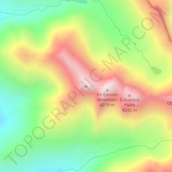
Nombre: Mapa topográfico Challenger Point, altitud, relieve.
Lugar: Challenger Point, Saguache County, Colorado, United States (37.98023 -105.60673 37.98033 -105.60663)
Altitud media: 3.781 m
Altitud mínima: 3.338 m
Altitud máxima: 4.314 m
Haz una donación
Otros mapas topográficos
Haga clic en un mapa para ver su topografía, su altitud y su relieve.
Great Sand Dunes National Park
United States > Colorado > Saguache County
In 1848, John C. Frémont was hired to find a railroad route from St. Louis to California. He crossed the Sangre de Cristos into the San Luis Valley in winter, courting disaster but proving that a winter crossing of this range was possible. He was followed in 1853 by Captain John Gunnison of the Corps of…
Altitud media: 2.616 m
Great Sand Dunes National Preserve
United States > Colorado > Saguache County
In 1848, John C. Frémont was hired to find a railroad route from St. Louis to California. He crossed the Sangre de Cristos into the San Luis Valley in winter, courting disaster but proving that a winter crossing of this range was possible. He was followed in 1853 by Captain John Gunnison of the Corps of…
Altitud media: 2.792 m
Haz una donación
Great Sand Dunes National Park
United States > Colorado > Saguache County
In 1848, John C. Frémont was hired to find a railroad route from St. Louis to California. He crossed the Sangre de Cristos into the San Luis Valley in winter, courting disaster but proving that a winter crossing of this range was possible. He was followed in 1853 by Captain John Gunnison of the Corps of…
Altitud media: 2.616 m