
Mapa topográfico Wachenheim an der Weinstraße
Mapa interactivo
Haga clic en el mapa para ver la altitud.
Acerca de este mapa
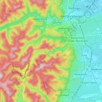
Nombre: Mapa topográfico Wachenheim an der Weinstraße, altitud, relieve.
Altitud media: 202 m
Altitud mínima: 101 m
Altitud máxima: 544 m
Auch nach dem Dreißigjährigen Krieg wurde die Region von Wachenheim immer wieder belagert, einer der Höhepunkte war der Pfälzer Erbfolgekrieg (1688–1697), in dessen Verlauf Wachenheim vollständig niedergebrannt wurde.
Otros mapas topográficos
Haga clic en un mapa para ver su topografía, su altitud y su relieve.
Bad Dürkheim
Deutschland > Rheinland-Pfalz > Landkreis Bad Dürkheim
Bad Dürkheim, Landkreis Bad Dürkheim, Rheinland-Pfalz, 67098, Deutschland
Altitud media: 216 m
Dirmstein
Deutschland > Rheinland-Pfalz > Landkreis Bad Dürkheim
Dirmstein, Leiningerland, Landkreis Bad Dürkheim, Rheinland-Pfalz, 67246, Deutschland
Altitud media: 129 m
Hornesselwiese
Deutschland > Rheinland-Pfalz > Landkreis Bad Dürkheim > Elmstein
Hornesselwiese, Elmstein, Lambrecht (Pfalz), Landkreis Bad Dürkheim, Rheinland-Pfalz, 67471, Deutschland
Altitud media: 372 m
67454
Deutschland > Rheinland-Pfalz > Landkreis Bad Dürkheim > Haßloch
67454, Haßloch, Landkreis Bad Dürkheim, Rheinland-Pfalz, Deutschland
Altitud media: 114 m
67246
Deutschland > Rheinland-Pfalz > Landkreis Bad Dürkheim > Dirmstein
67246, Dirmstein, Leiningerland, Landkreis Bad Dürkheim, Rheinland-Pfalz, Deutschland
Altitud media: 127 m
Haßloch
Deutschland > Rheinland-Pfalz > Landkreis Bad Dürkheim
Haßloch, Landkreis Bad Dürkheim, Rheinland-Pfalz, 67454, Deutschland
Altitud media: 115 m
Tiefenthal
Deutschland > Rheinland-Pfalz > Landkreis Bad Dürkheim
Tiefenthal, Leiningerland, Landkreis Bad Dürkheim, Rheinland-Pfalz, 67311, Deutschland
Altitud media: 251 m
Frankeneck
Deutschland > Rheinland-Pfalz > Landkreis Bad Dürkheim
Frankeneck, Lambrecht (Pfalz), Landkreis Bad Dürkheim, Rheinland-Pfalz, Deutschland
Altitud media: 325 m
Bad Dürkheim
Deutschland > Rheinland-Pfalz > Landkreis Bad Dürkheim
Bad Dürkheim, Landkreis Bad Dürkheim, Rheinland-Pfalz, 67098, Deutschland, Isenachweiher
Altitud media: 315 m
Friedelsheim
Deutschland > Rheinland-Pfalz > Landkreis Bad Dürkheim
Friedelsheim, Wachenheim an der Weinstraße, Landkreis Bad Dürkheim, Rheinland-Pfalz, 67159, Deutschland
Altitud media: 124 m
Kirchheim an der Weinstraße
Deutschland > Rheinland-Pfalz > Landkreis Bad Dürkheim
Kirchheim an der Weinstraße, Leiningerland, Landkreis Bad Dürkheim, Rheinland-Pfalz, 67281, Deutschland
Altitud media: 193 m
Deidesheim
Deutschland > Rheinland-Pfalz > Landkreis Bad Dürkheim
Deidesheim, Landkreis Bad Dürkheim, Rheinland-Pfalz, 67146, Deutschland
Altitud media: 194 m
Grünstadt
Deutschland > Rheinland-Pfalz > Landkreis Bad Dürkheim
Grünstadt, Landkreis Bad Dürkheim, Rheinland-Pfalz, Deutschland
Altitud media: 208 m
Forst an der Weinstraße
Deutschland > Rheinland-Pfalz > Landkreis Bad Dürkheim
Forst an der Weinstraße, Deidesheim, Landkreis Bad Dürkheim, Rheinland-Pfalz, 67147, Deutschland
Altitud media: 171 m
Harzofen
Deutschland > Rheinland-Pfalz > Landkreis Bad Dürkheim > Appenthal
Harzofen, Appenthal, Elmstein, Lambrecht (Pfalz), Landkreis Bad Dürkheim, Rheinland-Pfalz, 67471, Deutschland
Altitud media: 348 m
Elsa Host-Brunnen
Deutschland > Rheinland-Pfalz > Landkreis Bad Dürkheim > Weidenthal
Elsa Host-Brunnen, B 39, Weidenthal, Lambrecht (Pfalz), Landkreis Bad Dürkheim, Rheinland-Pfalz, 67475, Deutschland
Altitud media: 326 m
Mollenkopf
Deutschland > Rheinland-Pfalz > Landkreis Bad Dürkheim > Weidenthal
Mollenkopf, Weidenthal, Lambrecht (Pfalz), Landkreis Bad Dürkheim, Rheinland-Pfalz, 67472, Deutschland
Altitud media: 393 m
Lindenberg
Deutschland > Rheinland-Pfalz > Landkreis Bad Dürkheim
Lindenberg, Lambrecht (Pfalz), Landkreis Bad Dürkheim, Rheinland-Pfalz, 67473, Deutschland
Altitud media: 338 m
Iggelbach
Deutschland > Rheinland-Pfalz > Landkreis Bad Dürkheim
Iggelbach, Elmstein, Lambrecht (Pfalz), Landkreis Bad Dürkheim, Rheinland-Pfalz, 67471, Deutschland
Altitud media: 391 m
Weisenheim am Berg
Deutschland > Rheinland-Pfalz > Landkreis Bad Dürkheim
Weisenheim am Berg, Freinsheim, Landkreis Bad Dürkheim, Rheinland-Pfalz, 67273, Deutschland
Altitud media: 230 m
Geisskopf
Deutschland > Rheinland-Pfalz > Landkreis Bad Dürkheim > Elmstein
Geisskopf, Elmstein, Lambrecht (Pfalz), Landkreis Bad Dürkheim, Rheinland-Pfalz, 67471, Deutschland
Altitud media: 378 m
Hettenleidelheim
Deutschland > Rheinland-Pfalz > Landkreis Bad Dürkheim
Hettenleidelheim, Leiningerland, Landkreis Bad Dürkheim, Rheinland-Pfalz, 67310, Deutschland
Altitud media: 266 m
Gerolsheim
Deutschland > Rheinland-Pfalz > Landkreis Bad Dürkheim
Gerolsheim, Leiningerland, Landkreis Bad Dürkheim, Rheinland-Pfalz, Deutschland
Altitud media: 108 m
Quirnheim
Deutschland > Rheinland-Pfalz > Landkreis Bad Dürkheim
Quirnheim, Leiningerland, Landkreis Bad Dürkheim, Rheinland-Pfalz, 67280, Deutschland
Altitud media: 243 m
Lambrecht (Pfalz)
Deutschland > Rheinland-Pfalz > Landkreis Bad Dürkheim
Lambrecht (Pfalz), Landkreis Bad Dürkheim, Rheinland-Pfalz, Deutschland
Altitud media: 382 m
Dackenheim
Deutschland > Rheinland-Pfalz > Landkreis Bad Dürkheim > Dackenheim
Dackenheim, Freinsheim, Landkreis Bad Dürkheim, Rheinland-Pfalz, Deutschland
Altitud media: 188 m
Elmstein
Deutschland > Rheinland-Pfalz > Landkreis Bad Dürkheim
Elmstein, Lambrecht (Pfalz), Landkreis Bad Dürkheim, Rheinland-Pfalz, 67471, Deutschland
Altitud media: 385 m
Freinsheim
Deutschland > Rheinland-Pfalz > Landkreis Bad Dürkheim
Freinsheim, Landkreis Bad Dürkheim, Rheinland-Pfalz, 67251, Deutschland
Altitud media: 154 m
Carlsberg
Deutschland > Rheinland-Pfalz > Landkreis Bad Dürkheim
Carlsberg, Leiningerland, Landkreis Bad Dürkheim, Rheinland-Pfalz, 67316, Deutschland
Altitud media: 327 m
Lambrecht
Deutschland > Rheinland-Pfalz > Landkreis Bad Dürkheim
Lambrecht, Lambrecht (Pfalz), Landkreis Bad Dürkheim, Rheinland-Pfalz, 67466, Deutschland
Altitud media: 325 m
Ellerstadt
Deutschland > Rheinland-Pfalz > Landkreis Bad Dürkheim > Ellerstadt
Ellerstadt, Wachenheim an der Weinstraße, Landkreis Bad Dürkheim, Rheinland-Pfalz, 67158, Deutschland
Altitud media: 107 m
Weidenthal
Deutschland > Rheinland-Pfalz > Landkreis Bad Dürkheim
Weidenthal, Lambrecht (Pfalz), Landkreis Bad Dürkheim, Rheinland-Pfalz, 67475, Deutschland
Altitud media: 343 m
Hertlingshausen
Deutschland > Rheinland-Pfalz > Landkreis Bad Dürkheim
Hertlingshausen, Carlsberg, Leiningerland, Landkreis Bad Dürkheim, Rheinland-Pfalz, 67316, Deutschland
Altitud media: 331 m
Erpolzheim
Deutschland > Rheinland-Pfalz > Landkreis Bad Dürkheim
Erpolzheim, Freinsheim, Landkreis Bad Dürkheim, Rheinland-Pfalz, 67167, Deutschland
Altitud media: 110 m
Weisenheim am Sand
Deutschland > Rheinland-Pfalz > Landkreis Bad Dürkheim
Weisenheim am Sand, Freinsheim, Landkreis Bad Dürkheim, Rheinland-Pfalz, 67256, Deutschland
Altitud media: 133 m
Laumersheim
Deutschland > Rheinland-Pfalz > Landkreis Bad Dürkheim
Laumersheim, Leiningerland, Landkreis Bad Dürkheim, Rheinland-Pfalz, 67229, Deutschland
Altitud media: 124 m
Altleiningen
Deutschland > Rheinland-Pfalz > Landkreis Bad Dürkheim > Altleiningen
Altleiningen, Leiningerland, Landkreis Bad Dürkheim, Rheinland-Pfalz, 67317, Deutschland
Altitud media: 324 m
Herxheim am Berg
Deutschland > Rheinland-Pfalz > Landkreis Bad Dürkheim
Herxheim am Berg, Freinsheim, Landkreis Bad Dürkheim, Rheinland-Pfalz, Deutschland
Altitud media: 197 m
Esthal
Deutschland > Rheinland-Pfalz > Landkreis Bad Dürkheim > Esthal
Esthal, Lambrecht (Pfalz), Landkreis Bad Dürkheim, Rheinland-Pfalz, 67472, Deutschland
Altitud media: 351 m
Obrigheim (Pfalz)
Deutschland > Rheinland-Pfalz > Landkreis Bad Dürkheim
Obrigheim (Pfalz), Leiningerland, Landkreis Bad Dürkheim, Rheinland-Pfalz, 67283, Deutschland
Altitud media: 153 m
Leistadt
Deutschland > Rheinland-Pfalz > Landkreis Bad Dürkheim > Bad Dürkheim
Leistadt, Bad Dürkheim, Landkreis Bad Dürkheim, Rheinland-Pfalz, 67169, Deutschland
Altitud media: 242 m
Niederkirchen bei Deidesheim
Deutschland > Rheinland-Pfalz > Landkreis Bad Dürkheim
Niederkirchen bei Deidesheim, Deidesheim, Landkreis Bad Dürkheim, Rheinland-Pfalz, 67150, Deutschland
Altitud media: 111 m
Wattenheim
Deutschland > Rheinland-Pfalz > Landkreis Bad Dürkheim > Wattenheim
Wattenheim, Leiningerland, Landkreis Bad Dürkheim, Rheinland-Pfalz, 67319, Deutschland
Altitud media: 319 m
Meckenheim
Deutschland > Rheinland-Pfalz > Landkreis Bad Dürkheim
Meckenheim, Deidesheim, Landkreis Bad Dürkheim, Rheinland-Pfalz, 67149, Deutschland
Altitud media: 114 m
Kindenheim
Deutschland > Rheinland-Pfalz > Landkreis Bad Dürkheim
Kindenheim, Leiningerland, Landkreis Bad Dürkheim, Rheinland-Pfalz, Deutschland
Altitud media: 237 m
Stenzelberg
Deutschland > Rheinland-Pfalz > Landkreis Bad Dürkheim > Lindenberg
Stenzelberg, Lindenberg, Lambrecht (Pfalz), Landkreis Bad Dürkheim, Rheinland-Pfalz, 67473, Deutschland
Altitud media: 282 m