
Haz una donación
Mapa topográfico Mount Sherman
Haga clic en el mapa para ver la altitud.
Haz una donación
Acerca de este mapa
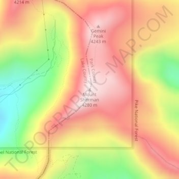
Nombre: Mapa topográfico Mount Sherman, altitud, relieve.
Lugar: Mount Sherman, Lake County, Colorado, United States (39.22503 -106.17012 39.22513 -106.17002)
Altitud media: 3.989 m
Altitud mínima: 3.587 m
Altitud máxima: 4.278 m
Haz una donación
Otros mapas topográficos
Haga clic en un mapa para ver su topografía, su altitud y su relieve.
Leadville
United States > Colorado > Lake County
The City of Leadville is a statutory city that is the county seat, the most populous community, and the only incorporated municipality in Lake County, Colorado, United States. The city population was 2,602 at the 2010 census and an estimated 2,762 in 2018. It is situated at an elevation of 10,152 feet (3,094…
Altitud media: 3.107 m
Mount Massive Wilderness
United States > Colorado > Lake County
The Mount Massive Wilderness is a federally designated wilderness area in the Sawatch Range, located in the U.S. state of Colorado. It is operated jointly by the United States Forest Service and the Fish and Wildlife Service as part of the San Isabel National Forest and the Leadville National Fish Hatchery. It…
Altitud media: 3.432 m
Leadville
United States > Colorado > Lake County
The City of Leadville is a statutory city that is the county seat, the most populous community, and the only incorporated municipality in Lake County, Colorado, United States. The city population was 2,602 at the 2010 census and an estimated 2,762 in 2018. It is situated at an elevation of 10,152 feet (3,094…
Altitud media: 3.107 m