
Haz una donación
Mapa topográfico Ballhausen
Haga clic en el mapa para ver la altitud.
Haz una donación
Acerca de este mapa
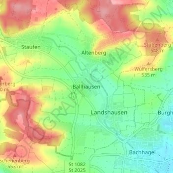
Nombre: Mapa topográfico Ballhausen, altitud, relieve.
Altitud media: 511 m
Altitud mínima: 465 m
Altitud máxima: 567 m
Haz una donación
Otros mapas topográficos
Haga clic en un mapa para ver su topografía, su altitud y su relieve.
Glött
Deutschland > Bayern > Landkreis Dillingen an der Donau
Im August 2007 wurde in Glött die erste Windkraftanlage im Landkreis Dillingen errichtet. Es handelt sich dabei um eine Enercon E-53 mit Nabenhöhe 73 m, Rotordurchmesser 53 m und einer Leistung von 800 kW.
Altitud media: 455 m
Wertingen
Deutschland > Bayern > Landkreis Dillingen an der Donau
Die Stadt an der unteren Zusam, die wenige Kilometer nördlich in die Donau mündet, wird von einem langgezogenen Höhenrücken vom Donauried getrennt. Wertingen liegt im großen Naturpark Augsburg-Westliche Wälder, der von den Flüssen Donau, Lech, Wertach und Mindel begrenzt wird. Augsburg ist 28 km,…
Altitud media: 445 m
Haz una donación
Haz una donación
Haz una donación
Gundelfingen an der Donau (VGem)
Deutschland > Bayern > Landkreis Dillingen an der Donau
Altitud media: 452 m
Aislingen
Deutschland > Bayern > Landkreis Dillingen an der Donau
Auf den südlichen Höhen befand sich ein römisches Erdkastell, unter dem Kaiser Tiberius errichtet, das etwa 68/69 n. Chr. zerstört wurde. In der Nähe wurde 1989/90 ein römisches Lagerdorf ergraben. An der heutigen westlichen Flurgrenze verlief auf rund drei Kilometer eine römische Straße, die bei…
Altitud media: 452 m
Haz una donación
89423
Deutschland > Bayern > Landkreis Dillingen an der Donau > Gundelfingen an der Donau > Peterswörth
Altitud media: 442 m
Haz una donación
Gundelfingen an der Donau
Deutschland > Bayern > Landkreis Dillingen an der Donau
Altitud media: 442 m
89420
Deutschland > Bayern > Landkreis Dillingen an der Donau > Höchstädt an der Donau
Altitud media: 439 m
Haz una donación
Blindheim
Deutschland > Bayern > Landkreis Dillingen an der Donau
2014 gab es nach der amtlichen Statistik 108 sozialversicherungspflichtig Beschäftigte am Arbeitsort Blindheim, davon waren 77 im produzierenden Gewerbe tätig. Sozialversicherungspflichtig Beschäftigte am Wohnort gab es 717. Die Zahl der Auspendler war um 609 höher als die der Einpendler. Fünf Einwohner…
Altitud media: 434 m
Lutzingen
Deutschland > Bayern > Landkreis Dillingen an der Donau
Im Jahr 2021 gab es nach der amtlichen Statistik 53 sozialversicherungspflichtig Beschäftigte am Arbeitsort Lutzingen. Sozialversicherungspflichtig Beschäftigte am Wohnort gab es 445. Die Zahl der Auspendler war um 392 höher als die der Einpendler. Neun Einwohner waren arbeitslos gemeldet. Im Jahr 2020 gab…
Altitud media: 477 m
Haz una donación
Wertingen
Deutschland > Bayern > Landkreis Dillingen an der Donau
Die Stadt an der unteren Zusam, die wenige Kilometer nördlich in die Donau mündet, wird von einem langgezogenen Höhenrücken vom Donauried getrennt. Wertingen liegt im großen Naturpark Augsburg-Westliche Wälder, der von den Flüssen Donau, Lech, Wertach und Mindel begrenzt wird. Augsburg ist 28 km,…
Altitud media: 446 m