
Haz una donación
Mapa topográfico Ocotillo
Haga clic en el mapa para ver la altitud.
Haz una donación
Acerca de este mapa
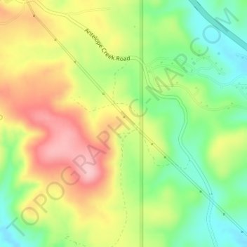
Nombre: Mapa topográfico Ocotillo, altitud, relieve.
Lugar: Ocotillo, Yavapai County, Arizona, 86333, United States (34.35364 -112.21183 34.37364 -112.19183)
Altitud media: 1.311 m
Altitud mínima: 1.236 m
Altitud máxima: 1.396 m
Haz una donación
Otros mapas topográficos
Haga clic en un mapa para ver su topografía, su altitud y su relieve.
Seligman
United States > Arizona > Yavapai County
Seligman is located at 35°19′42″N 112°52′27″W / 35.32833°N 112.87417°W / 35.32833; -112.87417 (35.328199, −112.874303), at 5,240 feet (1,600 m) in elevation, alongside the Big Chino Wash, in a northern section of Chino Valley. The wash is a major tributary of the Verde River. Seligman is…
Altitud media: 1.617 m
Sedona
United States > Arizona > Yavapai County
Sedona interior chaparral has many shrubs and small tree species of Quercus turbinella and Rhus ovata and a large population of Quercus palmeri. The Great Basin woodland has many small to medium trees of Pinus monophylla Var. fallax, Juniperus arizonica, Juniperus deppeana, Juniperus osteosperma, and Juniperus…
Altitud media: 1.342 m