
Haz una donación
Mapa topográfico Whitefish Lake
Haga clic en el mapa para ver la altitud.
Haz una donación
Acerca de este mapa
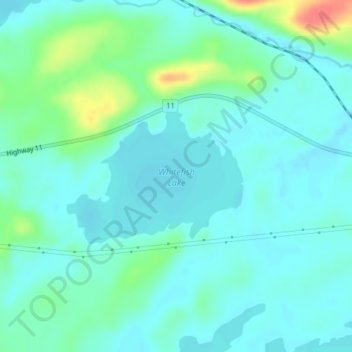
Nombre: Mapa topográfico Whitefish Lake, altitud, relieve.
Altitud media: 472 m
Altitud mínima: 459 m
Altitud máxima: 520 m
Haz una donación
Otros mapas topográficos
Haga clic en un mapa para ver su topografía, su altitud y su relieve.
Lac des Mille Lacs
Canada > Ontario > Thunder Bay District > Unorganized Thunder Bay District
Altitud media: 469 m
Tower Mountain
Canada > Ontario > Thunder Bay District > Unorganized Thunder Bay District
Altitud media: 575 m
Lower Ross Lake
Canada > Ontario > Thunder Bay District > Unorganized Thunder Bay District
Altitud media: 393 m
Quint Island Lake;Shacabac Creek
Canada > Ontario > Thunder Bay District > Unorganized Thunder Bay District
Altitud media: 283 m
Haz una donación
Upsala
Canada > Ontario > Thunder Bay District > Unorganized Thunder Bay District
Altitud media: 487 m
Whitefish Lake
Canada > Ontario > Thunder Bay District > Unorganized Thunder Bay District > Suomi
Altitud media: 456 m
Shebandowan
Canada > Ontario > Thunder Bay District > Unorganized Thunder Bay District
Altitud media: 461 m
Nolalu
Canada > Ontario > Thunder Bay District > Unorganized Thunder Bay District
Altitud media: 370 m
Haz una donación
Arrow Lake
Canada > Ontario > Thunder Bay District > Unorganized Thunder Bay District
Altitud media: 521 m
Pass Lake
Canada > Ontario > Thunder Bay District > Unorganized Thunder Bay District
Altitud media: 259 m
Miniss Lake
Canada > Ontario > Thunder Bay District > Unorganized Thunder Bay District
Altitud media: 394 m
Sleeping Giant Provincial Park
Canada > Ontario > Thunder Bay District > Unorganized Thunder Bay District
Altitud media: 204 m
Haz una donación
Perute Lake
Canada > Ontario > Thunder Bay District > Unorganized Thunder Bay District
Altitud media: 410 m
Harvey Lake
Canada > Ontario > Thunder Bay District > Unorganized Thunder Bay District
Altitud media: 297 m
Wapikaimaski Lake
Canada > Ontario > Thunder Bay District > Unorganized Thunder Bay District
Altitud media: 437 m
Sunshine
Canada > Ontario > Thunder Bay District > Unorganized Thunder Bay District
Altitud media: 401 m
Haz una donación
Horne Creek;Horne Lake
Canada > Ontario > Thunder Bay District > Unorganized Thunder Bay District
Altitud media: 443 m
Ruffle Lake
Canada > Ontario > Thunder Bay District > Unorganized Thunder Bay District
Altitud media: 326 m
Kapikotongwa River
Canada > Ontario > Thunder Bay District > Unorganized Thunder Bay District
Altitud media: 268 m
DeCourcey Lake
Canada > Ontario > Thunder Bay District > Unorganized Thunder Bay District
Altitud media: 457 m
Haz una donación
Shabaqua Corners
Canada > Ontario > Thunder Bay District > Unorganized Thunder Bay District
Altitud media: 416 m
Rossport
Canada > Ontario > Thunder Bay District > Unorganized Thunder Bay District
Altitud media: 227 m
Springpole Island
Canada > Ontario > Thunder Bay District > Unorganized Thunder Bay District
Altitud media: 289 m
Burness Lake
Canada > Ontario > Thunder Bay District > Unorganized Thunder Bay District
Altitud media: 301 m
Haz una donación
North Lake
Canada > Ontario > Thunder Bay District > Unorganized Thunder Bay District
Altitud media: 523 m
Whitesand Lake
Canada > Ontario > Thunder Bay District > Unorganized Thunder Bay District
Altitud media: 318 m
Georgia Lake
Canada > Ontario > Thunder Bay District > Unorganized Thunder Bay District
Altitud media: 459 m
Rossport
Canada > Ontario > Thunder Bay District > Unorganized Thunder Bay District
Altitud media: 227 m
Haz una donación
Sleeping Giant Provincial Park
Canada > Ontario > Thunder Bay District > Unorganized Thunder Bay District
Altitud media: 204 m
District Lake
Canada > Ontario > Thunder Bay District > Unorganized Thunder Bay District
Altitud media: 481 m