
Haz una donación
Mapa topográfico Zenar
Haga clic en el mapa para ver la altitud.
Haz una donación
Acerca de este mapa
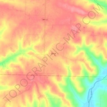
Nombre: Mapa topográfico Zenar, altitud, relieve.
Lugar: Zenar, Webster County, Missouri, 65642, United States (37.07505 -92.99045 37.11505 -92.95045)
Altitud media: 451 m
Altitud mínima: 390 m
Altitud máxima: 478 m
Haz una donación
Otros mapas topográficos
Haga clic en un mapa para ver su topografía, su altitud y su relieve.
Fordland
United States > Missouri > Webster County
Due to its higher elevation compared to Springfield, a tower farm for the market's television and FM radio stations is located in Fordland.
Altitud media: 480 m
Haz una donación
Fordland
United States > Missouri > Webster County
Due to favorable geographical conditions (e.g., altitude—Fordland is approximately 300 feet higher in elevation than Springfield), numerous Springfield-based media outlets, such as KYTV, KOLR, KOZL-TV, KGHZ, and others, have located their transmitting towers in or near Fordland.
Altitud media: 480 m
Haz una donación