
Mapa topográfico Monzingen
Mapa interactivo
Haga clic en el mapa para ver la altitud.
Acerca de este mapa
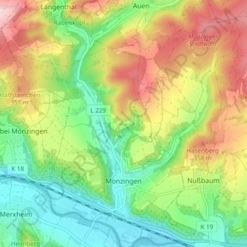
Nombre: Mapa topográfico Monzingen, altitud, relieve.
Altitud media: 261 m
Altitud mínima: 152 m
Altitud máxima: 415 m
Otros mapas topográficos
Haga clic en un mapa para ver su topografía, su altitud y su relieve.
Gebroth
Deutschland > Rheinland-Pfalz > Landkreis Bad Kreuznach
Gebroth, Rüdesheim, Landkreis Bad Kreuznach, Rheinland-Pfalz, Deutschland
Altitud media: 378 m
Obere Horbachsmühle
Deutschland > Rheinland-Pfalz > Landkreis Bad Kreuznach > Heimweiler
Obere Horbachsmühle, Heimweiler, Kirner Land, Landkreis Bad Kreuznach, Rheinland-Pfalz, 55606, Deutschland
Altitud media: 319 m
Winterbach
Deutschland > Rheinland-Pfalz > Landkreis Bad Kreuznach
Winterbach, Rüdesheim, Landkreis Bad Kreuznach, Rheinland-Pfalz, Deutschland
Altitud media: 467 m
55595
Deutschland > Rheinland-Pfalz > Landkreis Bad Kreuznach > Braunweiler
55595, Braunweiler, Rüdesheim, Landkreis Bad Kreuznach, Rheinland-Pfalz, Deutschland
Altitud media: 284 m
Hallgarten
Deutschland > Rheinland-Pfalz > Landkreis Bad Kreuznach
Hallgarten, Bad Kreuznach, Landkreis Bad Kreuznach, Rheinland-Pfalz, 67826, Deutschland
Altitud media: 296 m
Seesbach
Deutschland > Rheinland-Pfalz > Landkreis Bad Kreuznach
Seesbach, Nahe-Glan, Landkreis Bad Kreuznach, Rheinland-Pfalz, 55629, Deutschland
Altitud media: 385 m
Burgsponheim
Deutschland > Rheinland-Pfalz > Landkreis Bad Kreuznach
Burgsponheim, Rüdesheim, Landkreis Bad Kreuznach, Rheinland-Pfalz, Deutschland
Altitud media: 247 m
Simmertal
Deutschland > Rheinland-Pfalz > Landkreis Bad Kreuznach
Simmertal, Kirner Land, Landkreis Bad Kreuznach, Rheinland-Pfalz, 55618, Deutschland
Altitud media: 324 m
Bad Sobernheim
Deutschland > Rheinland-Pfalz > Landkreis Bad Kreuznach
Bad Sobernheim, Nahe-Glan, Landkreis Bad Kreuznach, Rheinland-Pfalz, 55566, Deutschland
Altitud media: 315 m
Heinzenberg
Deutschland > Rheinland-Pfalz > Landkreis Bad Kreuznach
Heinzenberg, Kirner Land, Landkreis Bad Kreuznach, Rheinland-Pfalz, Deutschland
Altitud media: 309 m
Meckenbacher Höhe
Deutschland > Rheinland-Pfalz > Landkreis Bad Kreuznach > Merxheim
Meckenbacher Höhe, Merxheim, Nahe-Glan, Landkreis Bad Kreuznach, Rheinland-Pfalz, 55606, Deutschland
Altitud media: 380 m
Stromberg
Deutschland > Rheinland-Pfalz > Landkreis Bad Kreuznach
Stromberg, Langenlonsheim-Stromberg, Landkreis Bad Kreuznach, Rheinland-Pfalz, Deutschland
Altitud media: 325 m
Bad Kreuznach
Deutschland > Rheinland-Pfalz > Landkreis Bad Kreuznach
Bad Kreuznach, Landkreis Bad Kreuznach, Rheinland-Pfalz, Deutschland
Altitud media: 180 m
Bad Münster am Stein-Ebernburg
Deutschland > Rheinland-Pfalz > Landkreis Bad Kreuznach > Bad Kreuznach
Bad Münster am Stein-Ebernburg, Bad Kreuznach, Landkreis Bad Kreuznach, Rheinland-Pfalz, 55583, Deutschland
Altitud media: 220 m
Kirn
Deutschland > Rheinland-Pfalz > Landkreis Bad Kreuznach
Kirn, Kirner Land, Landkreis Bad Kreuznach, Rheinland-Pfalz, 55606, Deutschland
Altitud media: 302 m
Spabrücken
Deutschland > Rheinland-Pfalz > Landkreis Bad Kreuznach
Spabrücken, Rüdesheim, Landkreis Bad Kreuznach, Rheinland-Pfalz, Deutschland
Altitud media: 405 m
Becherbach bei Kirn
Deutschland > Rheinland-Pfalz > Landkreis Bad Kreuznach
Becherbach bei Kirn, Kirner Land, Landkreis Bad Kreuznach, Rheinland-Pfalz, Deutschland
Altitud media: 321 m
Schweinschied
Deutschland > Rheinland-Pfalz > Landkreis Bad Kreuznach
Schweinschied, Nahe-Glan, Landkreis Bad Kreuznach, Rheinland-Pfalz, Deutschland
Altitud media: 306 m
Hargesheim
Deutschland > Rheinland-Pfalz > Landkreis Bad Kreuznach
Hargesheim, Rüdesheim, Landkreis Bad Kreuznach, Rheinland-Pfalz, Deutschland
Altitud media: 174 m
Breitenheim
Deutschland > Rheinland-Pfalz > Landkreis Bad Kreuznach
Breitenheim, Nahe-Glan, Landkreis Bad Kreuznach, Rheinland-Pfalz, Deutschland
Altitud media: 249 m
Meisenheim
Deutschland > Rheinland-Pfalz > Landkreis Bad Kreuznach
Meisenheim, Nahe-Glan, Landkreis Bad Kreuznach, Rheinland-Pfalz, 55590, Deutschland
Altitud media: 231 m
Rüdesheim (Nahe)
Deutschland > Rheinland-Pfalz > Landkreis Bad Kreuznach > Rüdesheim
Rüdesheim (Nahe), Rüdesheim, Landkreis Bad Kreuznach, Rheinland-Pfalz, 55593, Deutschland
Altitud media: 177 m
Meckenbach
Deutschland > Rheinland-Pfalz > Landkreis Bad Kreuznach
Meckenbach, Kirner Land, Landkreis Bad Kreuznach, Rheinland-Pfalz, 55606, Deutschland
Altitud media: 345 m
Guldental
Deutschland > Rheinland-Pfalz > Landkreis Bad Kreuznach
Guldental, Langenlonsheim-Stromberg, Landkreis Bad Kreuznach, Rheinland-Pfalz, Deutschland
Altitud media: 192 m
Biebelsheim
Deutschland > Rheinland-Pfalz > Landkreis Bad Kreuznach
Biebelsheim, Bad Kreuznach, Landkreis Bad Kreuznach, Rheinland-Pfalz, Deutschland
Altitud media: 130 m
Kirner Land
Deutschland > Rheinland-Pfalz > Landkreis Bad Kreuznach
Kirner Land, Landkreis Bad Kreuznach, Rheinland-Pfalz, Deutschland
Altitud media: 350 m
Langenlonsheim
Deutschland > Rheinland-Pfalz > Landkreis Bad Kreuznach
Langenlonsheim, Langenlonsheim-Stromberg, Landkreis Bad Kreuznach, Rheinland-Pfalz, Deutschland
Altitud media: 135 m
Laubenheim
Deutschland > Rheinland-Pfalz > Landkreis Bad Kreuznach > Laubenheim
Laubenheim, Langenlonsheim-Stromberg, Landkreis Bad Kreuznach, Rheinland-Pfalz, Deutschland
Altitud media: 131 m
Schweppenhausen
Deutschland > Rheinland-Pfalz > Landkreis Bad Kreuznach
Schweppenhausen, Langenlonsheim-Stromberg, Landkreis Bad Kreuznach, Rheinland-Pfalz, Deutschland
Altitud media: 247 m
Oberhausen an der Nahe
Deutschland > Rheinland-Pfalz > Landkreis Bad Kreuznach
Oberhausen an der Nahe, Rüdesheim, Landkreis Bad Kreuznach, Rheinland-Pfalz, Deutschland
Altitud media: 242 m
Weiler bei Monzingen
Deutschland > Rheinland-Pfalz > Landkreis Bad Kreuznach > Weiler bei Monzingen > Weiler bei Monzingen
Weiler bei Monzingen, Nahe-Glan, Landkreis Bad Kreuznach, Rheinland-Pfalz, 55627, Deutschland
Altitud media: 256 m
Hochstetten-Dhaun
Deutschland > Rheinland-Pfalz > Landkreis Bad Kreuznach
Hochstetten-Dhaun, Kirner Land, Landkreis Bad Kreuznach, Rheinland-Pfalz, Deutschland
Altitud media: 285 m
Langenthal
Deutschland > Rheinland-Pfalz > Landkreis Bad Kreuznach
Langenthal, Nahe-Glan, Landkreis Bad Kreuznach, Rheinland-Pfalz, Deutschland
Altitud media: 319 m
Hochstädten
Deutschland > Rheinland-Pfalz > Landkreis Bad Kreuznach > Hochstädten
Hochstädten, Hochstetten-Dhaun, Kirner Land, Landkreis Bad Kreuznach, Rheinland-Pfalz, 55618, Deutschland
Altitud media: 272 m
Windesheim
Deutschland > Rheinland-Pfalz > Landkreis Bad Kreuznach
Windesheim, Langenlonsheim-Stromberg, Landkreis Bad Kreuznach, Rheinland-Pfalz, Deutschland
Altitud media: 219 m
Neu-Bamberg
Deutschland > Rheinland-Pfalz > Landkreis Bad Kreuznach
Neu-Bamberg, Bad Kreuznach, Landkreis Bad Kreuznach, Rheinland-Pfalz, Deutschland
Altitud media: 199 m
Hackenheim
Deutschland > Rheinland-Pfalz > Landkreis Bad Kreuznach
Hackenheim, Bad Kreuznach, Landkreis Bad Kreuznach, Rheinland-Pfalz, Deutschland
Altitud media: 189 m
Sankt Katharinen
Deutschland > Rheinland-Pfalz > Landkreis Bad Kreuznach
Sankt Katharinen, Rüdesheim, Landkreis Bad Kreuznach, Rheinland-Pfalz, Deutschland
Altitud media: 224 m
Bockenau
Deutschland > Rheinland-Pfalz > Landkreis Bad Kreuznach
Bockenau, Rüdesheim, Landkreis Bad Kreuznach, Rheinland-Pfalz, 55595, Deutschland
Altitud media: 317 m
Weinsheim
Deutschland > Rheinland-Pfalz > Landkreis Bad Kreuznach > Weinsheim
Weinsheim, Rüdesheim, Landkreis Bad Kreuznach, Rheinland-Pfalz, Deutschland
Altitud media: 201 m
Lettweiler
Deutschland > Rheinland-Pfalz > Landkreis Bad Kreuznach > Lettweiler
Lettweiler, Nahe-Glan, Landkreis Bad Kreuznach, Rheinland-Pfalz, Deutschland
Altitud media: 315 m
Bruschied
Deutschland > Rheinland-Pfalz > Landkreis Bad Kreuznach
Bruschied, Kirner Land, Landkreis Bad Kreuznach, Rheinland-Pfalz, Deutschland
Altitud media: 389 m
Volxheim
Deutschland > Rheinland-Pfalz > Landkreis Bad Kreuznach > Volxheim
Volxheim, Bad Kreuznach, Landkreis Bad Kreuznach, Rheinland-Pfalz, 55546, Deutschland
Altitud media: 166 m
Montforterhof
Deutschland > Rheinland-Pfalz > Landkreis Bad Kreuznach > Duchroth > Montforterhof
Montforterhof, Duchroth, Rüdesheim, Landkreis Bad Kreuznach, Rheinland-Pfalz, Deutschland
Altitud media: 289 m
Eckenroth
Deutschland > Rheinland-Pfalz > Landkreis Bad Kreuznach > Eckenroth
Eckenroth, Langenlonsheim-Stromberg, Landkreis Bad Kreuznach, Rheinland-Pfalz, Deutschland
Altitud media: 291 m
Duchroth
Deutschland > Rheinland-Pfalz > Landkreis Bad Kreuznach
Duchroth, Rüdesheim, Landkreis Bad Kreuznach, Rheinland-Pfalz, Deutschland
Altitud media: 251 m
Hennweiler
Deutschland > Rheinland-Pfalz > Landkreis Bad Kreuznach
Hennweiler, Kirner Land, Landkreis Bad Kreuznach, Rheinland-Pfalz, 55619, Deutschland
Altitud media: 390 m
Odernheim am Glan
Deutschland > Rheinland-Pfalz > Landkreis Bad Kreuznach
Odernheim am Glan, Nahe-Glan, Landkreis Bad Kreuznach, Rheinland-Pfalz, 55571, Deutschland
Altitud media: 239 m
Münchwald
Deutschland > Rheinland-Pfalz > Landkreis Bad Kreuznach
Münchwald, Rüdesheim, Landkreis Bad Kreuznach, Rheinland-Pfalz, Deutschland
Altitud media: 398 m
Schneppenbach
Deutschland > Rheinland-Pfalz > Landkreis Bad Kreuznach
Schneppenbach, Kirner Land, Landkreis Bad Kreuznach, Rheinland-Pfalz, Deutschland
Altitud media: 388 m