
Mapa topográfico La Motte de Gemme
Mapa interactivo
Haga clic en el mapa para ver la altitud.
Acerca de este mapa
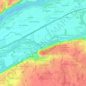
Nombre: Mapa topográfico La Motte de Gemme, altitud, relieve.
Altitud media: 61 m
Altitud mínima: 35 m
Altitud máxima: 98 m
Otros mapas topográficos
Haga clic en un mapa para ver su topografía, su altitud y su relieve.
Les Navets
France > Centre-Val de Loire > Indre-et-Loire > Villandry
Les Navets, Villandry, Tours, Indre-et-Loire, Centre-Val de Loire, France métropolitaine, 37510, France
Altitud media: 51 m
Le Château
France > Centre-Val de Loire > Indre-et-Loire > Villandry
Le Château, Villandry, Arrondissement de Tours, Indre-et-Loire, Centre-Val de Loire, France métropolitaine, 37510, France
Altitud media: 64 m
Le Barrage
France > Centre-Val de Loire > Indre-et-Loire > Villandry
Le Barrage, Villandry, Tours, Indre-et-Loire, Centre-Val de Loire, France métropolitaine, 37510, France
Altitud media: 57 m
Les Hucaudières
France > Centre-Val de Loire > Indre-et-Loire > Villandry
Les Hucaudières, Villandry, Arrondissement de Tours, Indre-et-Loire, Centre-Val de Loire, France métropolitaine, 37510, France
Altitud media: 60 m