
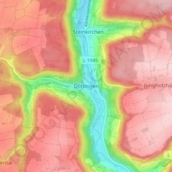
Mapa topográfico Döttingen
Mapa interactivo
Haga clic en el mapa para ver la altitud.
Acerca de este mapa
Nombre: Mapa topográfico Döttingen, altitud, relieve.
Altitud media: 374 m
Altitud mínima: 231 m
Altitud máxima: 457 m
Otros mapas topográficos
Haga clic en un mapa para ver su topografía, su altitud y su relieve.
Schwäbisch Hall
Deutschland > Baden-Württemberg > Landkreis Schwäbisch Hall
Schwäbisch Hall, Verwaltungsgemeinschaft Schwäbisch Hall, Landkreis Schwäbisch Hall, Baden-Württemberg, 74523, Deutschland
Altitud media: 410 m
74544
Deutschland > Baden-Württemberg > Landkreis Schwäbisch Hall > Michelbach an der Bilz > Hagenhof
74544, Hagenhof, Michelbach an der Bilz, Verwaltungsgemeinschaft Schwäbisch Hall, Landkreis Schwäbisch Hall, Baden-Württemberg, Deutschland
Altitud media: 403 m
Winzenweiler
Deutschland > Baden-Württemberg > Landkreis Schwäbisch Hall > Gaildorf
Winzenweiler, Eutendorf, Gaildorf, Verwaltungsverband Limpurger Land, Landkreis Schwäbisch Hall, Baden-Württemberg, 74405, Deutschland
Altitud media: 469 m
Kreßbronn
Deutschland > Baden-Württemberg > Landkreis Schwäbisch Hall > Stimpfach
Kreßbronn, Stimpfach, Verwaltungsverband Crailsheim, Landkreis Schwäbisch Hall, Baden-Württemberg, 74597, Deutschland
Altitud media: 476 m
74427
Deutschland > Baden-Württemberg > Landkreis Schwäbisch Hall > Fichtenberg
74427, Fichtenberg, Verwaltungsverband Limpurger Land, Landkreis Schwäbisch Hall, Baden-Württemberg, Deutschland
Altitud media: 396 m
Crailsheim
Deutschland > Baden-Württemberg > Landkreis Schwäbisch Hall
Crailsheim, Verwaltungsverband Crailsheim, Landkreis Schwäbisch Hall, Baden-Württemberg, 74564, Deutschland
Altitud media: 451 m
Schönbronn
Deutschland > Baden-Württemberg > Landkreis Schwäbisch Hall > Kreßberg
Schönbronn, Kreßberg, Verwaltungsverband Fichtenau, Landkreis Schwäbisch Hall, Baden-Württemberg, 74594, Deutschland
Altitud media: 483 m
Schwarzenlache
Deutschland > Baden-Württemberg > Landkreis Schwäbisch Hall > Schwäbisch Hall > Sulzdorf
Schwarzenlache, Sulzdorf, Schwäbisch Hall, Verwaltungsgemeinschaft Schwäbisch Hall, Landkreis Schwäbisch Hall, Baden-Württemberg, Deutschland
Altitud media: 412 m
Mittelmühle
Deutschland > Baden-Württemberg > Landkreis Schwäbisch Hall > Gailsbach
Mittelmühle, Gailsbach, Mainhardt, Landkreis Schwäbisch Hall, Baden-Württemberg, 74535, Deutschland
Altitud media: 465 m
Großenhub
Deutschland > Baden-Württemberg > Landkreis Schwäbisch Hall > Fichtenau
Großenhub, Fichtenau, Verwaltungsverband Fichtenau, Landkreis Schwäbisch Hall, Baden-Württemberg, 74579, Deutschland
Altitud media: 492 m
Altenhausen
Deutschland > Baden-Württemberg > Landkreis Schwäbisch Hall > Schwäbisch Hall
Altenhausen, Schwäbisch Hall, Verwaltungsgemeinschaft Schwäbisch Hall, Landkreis Schwäbisch Hall, Baden-Württemberg, 74523, Deutschland
Altitud media: 397 m
Untermünkheim
Deutschland > Baden-Württemberg > Landkreis Schwäbisch Hall
Untermünkheim, Verwaltungsverband Braunsbach-Untermünkheim, Landkreis Schwäbisch Hall, Baden-Württemberg, 74547, Deutschland
Altitud media: 376 m
Maibach
Deutschland > Baden-Württemberg > Landkreis Schwäbisch Hall > Bubenorbis
Maibach, Bubenorbis, Mainhardt, Landkreis Schwäbisch Hall, Baden-Württemberg, 74535, Deutschland
Altitud media: 469 m
Tiefenbach
Deutschland > Baden-Württemberg > Landkreis Schwäbisch Hall > Crailsheim
Tiefenbach, Crailsheim, Verwaltungsverband Crailsheim, Landkreis Schwäbisch Hall, Baden-Württemberg, 74564, Deutschland
Altitud media: 424 m
Lachweiler
Deutschland > Baden-Württemberg > Landkreis Schwäbisch Hall
Lachweiler, Mainhardt, Landkreis Schwäbisch Hall, Baden-Württemberg, 74535, Deutschland
Altitud media: 461 m
Hegenhäule
Deutschland > Baden-Württemberg > Landkreis Schwäbisch Hall > Lachweiler
Hegenhäule, Lachweiler, Mainhardt, Landkreis Schwäbisch Hall, Baden-Württemberg, 74535, Deutschland
Altitud media: 451 m
Leuzendorf
Deutschland > Baden-Württemberg > Landkreis Schwäbisch Hall > Schrozberg
Leuzendorf, Schrozberg, Landkreis Schwäbisch Hall, Baden-Württemberg, Deutschland
Altitud media: 463 m
Sandhof
Deutschland > Baden-Württemberg > Landkreis Schwäbisch Hall > Frankenhardt > Honhardt
Sandhof, Honhardt, Frankenhardt, Verwaltungsverband Crailsheim, Landkreis Schwäbisch Hall, Baden-Württemberg, 74586, Deutschland
Altitud media: 460 m
Dörrenzimmern
Deutschland > Baden-Württemberg > Landkreis Schwäbisch Hall > Schwäbisch Hall
Dörrenzimmern, Schwäbisch Hall, Verwaltungsgemeinschaft Schwäbisch Hall, Landkreis Schwäbisch Hall, Baden-Württemberg, 74541, Deutschland
Altitud media: 399 m
Unterrot
Deutschland > Baden-Württemberg > Landkreis Schwäbisch Hall > Gaildorf
Unterrot, Gaildorf, Verwaltungsverband Limpurger Land, Landkreis Schwäbisch Hall, Baden-Württemberg, Deutschland
Altitud media: 416 m
Hengstfeld
Deutschland > Baden-Württemberg > Landkreis Schwäbisch Hall
Hengstfeld, Wallhausen, Verwaltungsverband Brettach/Jagst, Landkreis Schwäbisch Hall, Baden-Württemberg, 74599, Deutschland
Altitud media: 456 m
Gaildorf
Deutschland > Baden-Württemberg > Landkreis Schwäbisch Hall
Gaildorf, Verwaltungsverband Limpurger Land, Landkreis Schwäbisch Hall, Baden-Württemberg, 74405, Deutschland
Altitud media: 420 m
Westgartshausen
Deutschland > Baden-Württemberg > Landkreis Schwäbisch Hall > Crailsheim
Westgartshausen, Crailsheim, Verwaltungsverband Crailsheim, Landkreis Schwäbisch Hall, Baden-Württemberg, Deutschland
Altitud media: 465 m
Mainhardt
Deutschland > Baden-Württemberg > Landkreis Schwäbisch Hall
Mainhardt, Landkreis Schwäbisch Hall, Baden-Württemberg, 74535, Deutschland
Altitud media: 455 m
Waldtann
Deutschland > Baden-Württemberg > Landkreis Schwäbisch Hall > Kreßberg
Waldtann, Kreßberg, Verwaltungsverband Fichtenau, Landkreis Schwäbisch Hall, Baden-Württemberg, 74594, Deutschland
Altitud media: 485 m
Schrozberg
Deutschland > Baden-Württemberg > Landkreis Schwäbisch Hall
Schrozberg, Landkreis Schwäbisch Hall, Baden-Württemberg, 74575, Deutschland
Altitud media: 448 m
Bubenorbis
Deutschland > Baden-Württemberg > Landkreis Schwäbisch Hall
Bubenorbis, Mainhardt, Landkreis Schwäbisch Hall, Baden-Württemberg, 74535, Deutschland
Altitud media: 472 m
Rot am See
Deutschland > Baden-Württemberg > Landkreis Schwäbisch Hall
Rot am See, Verwaltungsverband Brettach/Jagst, Landkreis Schwäbisch Hall, Baden-Württemberg, 74585, Deutschland
Altitud media: 450 m
Kirchberg an der Jagst
Deutschland > Baden-Württemberg > Landkreis Schwäbisch Hall
Kirchberg an der Jagst, Verwaltungsverband Brettach/Jagst, Landkreis Schwäbisch Hall, Baden-Württemberg, 74592, Deutschland
Altitud media: 416 m
Hessental
Deutschland > Baden-Württemberg > Landkreis Schwäbisch Hall > Schwäbisch Hall
Hessental, Schwäbisch Hall, Verwaltungsgemeinschaft Schwäbisch Hall, Landkreis Schwäbisch Hall, Baden-Württemberg, 74523, Deutschland
Altitud media: 394 m
Eckartshausen
Deutschland > Baden-Württemberg > Landkreis Schwäbisch Hall > Ilshofen
Eckartshausen, Ilshofen, Verwaltungsverband Ilshofen-Vellberg, Landkreis Schwäbisch Hall, Baden-Württemberg, 74532, Deutschland
Altitud media: 436 m
Ramsbach
Deutschland > Baden-Württemberg > Landkreis Schwäbisch Hall > Schwäbisch Hall
Ramsbach, Schwäbisch Hall, Verwaltungsgemeinschaft Schwäbisch Hall, Landkreis Schwäbisch Hall, Baden-Württemberg, 74549, Deutschland
Altitud media: 391 m
Einkorn
Deutschland > Baden-Württemberg > Landkreis Schwäbisch Hall > Schwäbisch Hall
Einkorn, Schwäbisch Hall, Verwaltungsgemeinschaft Schwäbisch Hall, Landkreis Schwäbisch Hall, Baden-Württemberg, 74544, Deutschland
Altitud media: 412 m
Billingsbach
Deutschland > Baden-Württemberg > Landkreis Schwäbisch Hall
Billingsbach, Blaufelden, Landkreis Schwäbisch Hall, Baden-Württemberg, Deutschland
Altitud media: 459 m
Gerabronn
Deutschland > Baden-Württemberg > Landkreis Schwäbisch Hall
Gerabronn, Verwaltungsgemeinschaft Gerabronn, Landkreis Schwäbisch Hall, Baden-Württemberg, 74582, Deutschland
Altitud media: 432 m
Rappenhof
Deutschland > Baden-Württemberg > Landkreis Schwäbisch Hall > Mainhardt
Rappenhof, Mainhardt, Landkreis Schwäbisch Hall, Baden-Württemberg, 74535, Deutschland
Altitud media: 429 m
Steinbach
Deutschland > Baden-Württemberg > Landkreis Schwäbisch Hall > Schwäbisch Hall
Steinbach, Schwäbisch Hall, Verwaltungsgemeinschaft Schwäbisch Hall, Landkreis Schwäbisch Hall, Baden-Württemberg, 74523, Deutschland
Altitud media: 362 m
Blaufelden
Deutschland > Baden-Württemberg > Landkreis Schwäbisch Hall
Blaufelden, Landkreis Schwäbisch Hall, Baden-Württemberg, 74572, Deutschland
Altitud media: 449 m
Oberrot
Deutschland > Baden-Württemberg > Landkreis Schwäbisch Hall
Oberrot, Verwaltungsverband Limpurger Land, Landkreis Schwäbisch Hall, Baden-Württemberg, 74420, Deutschland
Altitud media: 440 m
Wolfenbrück
Deutschland > Baden-Württemberg > Landkreis Schwäbisch Hall > Oberrot > Wolfenbrück
Wolfenbrück, Oberrot, Verwaltungsverband Limpurger Land, Landkreis Schwäbisch Hall, Baden-Württemberg, 71540, Deutschland
Altitud media: 463 m
Langenburg
Deutschland > Baden-Württemberg > Landkreis Schwäbisch Hall
Langenburg, Verwaltungsgemeinschaft Gerabronn, Landkreis Schwäbisch Hall, Baden-Württemberg, 74595, Deutschland
Altitud media: 432 m
Gnadental
Deutschland > Baden-Württemberg > Landkreis Schwäbisch Hall
Gnadental, Michelfeld, Verwaltungsgemeinschaft Schwäbisch Hall, Landkreis Schwäbisch Hall, Baden-Württemberg, 74545, Deutschland
Altitud media: 452 m
Oberscheffach
Deutschland > Baden-Württemberg > Landkreis Schwäbisch Hall > Ilshofen > Oberscheffach
Oberscheffach, Ilshofen, Verwaltungsverband Ilshofen-Vellberg, Landkreis Schwäbisch Hall, Baden-Württemberg, 74541, Deutschland
Altitud media: 385 m
Michelbach an der Bilz
Deutschland > Baden-Württemberg > Landkreis Schwäbisch Hall
Michelbach an der Bilz, Verwaltungsgemeinschaft Schwäbisch Hall, Landkreis Schwäbisch Hall, Baden-Württemberg, 74544, Deutschland
Altitud media: 399 m
Löwenburg
Deutschland > Baden-Württemberg > Landkreis Schwäbisch Hall > Geislingen am Kocher
Löwenburg, K 2557, Geislingen am Kocher, Braunsbach, Verwaltungsverband Braunsbach-Untermünkheim, Landkreis Schwäbisch Hall, Baden-Württemberg, 74542, Deutschland
Altitud media: 357 m
Kreßberg
Deutschland > Baden-Württemberg > Landkreis Schwäbisch Hall
Kreßberg, Verwaltungsverband Fichtenau, Landkreis Schwäbisch Hall, Baden-Württemberg, 74594, Deutschland
Altitud media: 485 m
Binselberg
Deutschland > Baden-Württemberg > Landkreis Schwäbisch Hall > Gerabronn > Binselberg
Binselberg, Gerabronn, Verwaltungsgemeinschaft Gerabronn, Landkreis Schwäbisch Hall, Baden-Württemberg, 74595, Deutschland
Altitud media: 415 m
Michelfeld
Deutschland > Baden-Württemberg > Landkreis Schwäbisch Hall
Michelfeld, Verwaltungsgemeinschaft Schwäbisch Hall, Landkreis Schwäbisch Hall, Baden-Württemberg, 74545, Deutschland
Altitud media: 406 m
Neuhofen
Deutschland > Baden-Württemberg > Landkreis Schwäbisch Hall > Schwäbisch Hall > Wackershofen > Neuhofen
Neuhofen, Wackershofen, Schwäbisch Hall, Verwaltungsgemeinschaft Schwäbisch Hall, Landkreis Schwäbisch Hall, Baden-Württemberg, 74547, Deutschland
Altitud media: 363 m
Dünsbach
Deutschland > Baden-Württemberg > Landkreis Schwäbisch Hall > Gerabronn
Dünsbach, Gerabronn, Verwaltungsgemeinschaft Gerabronn, Landkreis Schwäbisch Hall, Baden-Württemberg, 74582, Deutschland
Altitud media: 420 m