
Mapa topográfico West Hartford
Mapa interactivo
Haga clic en el mapa para ver la altitud.
West Hartford
The west side of West Hartford is flanked by the Metacomet Ridge, a mountainous trap rock ridgeline that stretches from Long Island Sound to nearly the Vermont border. Notable features of the Metacomet Ridge in West Hartford include Talcott Mountain and a number of highland water reservoirs belonging to the Metropolitan District, which maintains watershed and recreation resources on the property. The 51-mile-long (82 km) Metacomet Trail traverses the ridge. The town's web site indicates that the highest point in town is 778 feet (237 m) above sea level on Talcott (Avon) Mountain. The altitude at Town Hall is 120 feet (37 m).
Acerca de este mapa
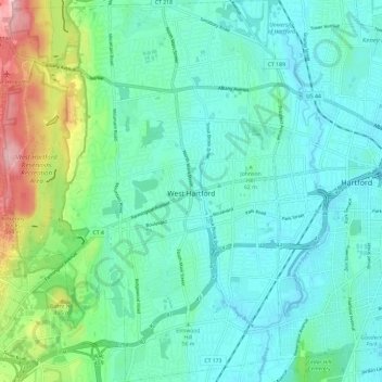
Nombre: Mapa topográfico West Hartford, altitud, relieve.
Altitud media: 60 m
Altitud mínima: 9 m
Altitud máxima: 250 m
Otros mapas topográficos
Haga clic en un mapa para ver su topografía, su altitud y su relieve.
Griswoldville
United States > Connecticut > Capitol Planning Region > Wethersfield
Altitud media: 34 m
Johnson Hill
United States > Connecticut > Capitol Planning Region > West Hartford
Altitud media: 34 m
Talcott Mountain
United States > Connecticut > Capitol Planning Region > Bloomfield
Altitud media: 152 m
Stafford Springs
United States > Connecticut > Capitol Planning Region > Stafford
Altitud media: 200 m
Barbara Drive
United States > Connecticut > Capitol Planning Region > Windsor Locks
Altitud media: 39 m
Fernridge Place
United States > Connecticut > Capitol Planning Region > West Hartford
Altitud media: 40 m
Whitings Corner
United States > Connecticut > Capitol Planning Region > West Hartford
Altitud media: 84 m