
Mapa topográfico Jurong Hill
Mapa interactivo
Haga clic en el mapa para ver la altitud.
Acerca de este mapa
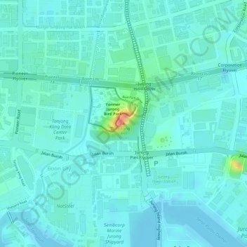
Nombre: Mapa topográfico Jurong Hill, altitud, relieve.
Lugar: Jurong Hill, Southwest, 628925, Singapore (1.31739 103.70781 1.31749 103.70791)
Altitud media: 11 m
Altitud mínima: -1 m
Altitud máxima: 60 m
Otros mapas topográficos
Haga clic en un mapa para ver su topografía, su altitud y su relieve.
Bajau Hill
Singapore > Southwest > Singapore
Bajau Hill, Singapore, Southwest, 636921, Singapore
Altitud media: 15 m
Tanjong Pasir Laba
Tanjong Pasir Laba, Western Water Catchment, Southwest, 639937, Singapore
Altitud media: 4 m
Kent Ridge Park
Singapore > Southwest > Queenstown
Kent Ridge Park, Alexandra, Queenstown, Southwest, Singapore
Altitud media: 21 m