
Haz una donación
Mapa topográfico Stechlin
Haga clic en el mapa para ver la altitud.
Haz una donación
Acerca de este mapa
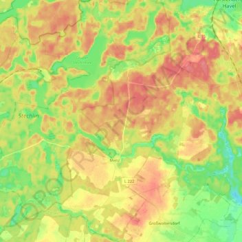
Nombre: Mapa topográfico Stechlin, altitud, relieve.
Altitud media: 73 m
Altitud mínima: 39 m
Altitud máxima: 103 m
Haz una donación
Otros mapas topográficos
Haga clic en un mapa para ver su topografía, su altitud y su relieve.
Haz una donación
Haz una donación
Haz una donación
Nassenheide
Deutschland > Brandenburg > Oberhavel
Die Kirche Löwenberg gehört zum Evangelischen Kirchenkreis Oberes Havelland der evangelischen Landeskirche. Sie ist ein frühgotischer Feldsteinbau mit einem eingezogenen Chor und einem Breitturm (Höhe 19,5 m, Grundfläche 86,4 m²) an der Westseite. Die ältesten Teile der Kirche stammen aus dem 13.…
Altitud media: 39 m
Haz una donación
Steinhavelmühle
Deutschland > Brandenburg > Oberhavel > Fürstenberg/Havel > Steinförde
Altitud media: 64 m
Großer Stechlinsee
Deutschland > Brandenburg > Oberhavel > Rheinsberg
Der Große Stechlinsee gehört zum Rheinsberger Seengebiet im Naturraum des Neustrelitzer Kleinseenlandes. Er liegt auf dem Gebiet der Gemeinde Stechlin im Landkreis Oberhavel. Das Westufer gehört zum Gebiet der Stadt Rheinsberg im Landkreis Ostprignitz-Ruppin. Am Ostufer liegt das Dorf Neuglobsow. Die…
Altitud media: 72 m
Haz una donación
Kleiner Wentowsee
Deutschland > Brandenburg > Oberhavel > Gransee > Dannenwalde > Seilershof
Altitud media: 55 m
Haz una donación