
Mapa topográfico Holzweiler
Mapa interactivo
Haga clic en el mapa para ver la altitud.
Acerca de este mapa
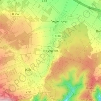
Nombre: Mapa topográfico Holzweiler, altitud, relieve.
Altitud media: 256 m
Altitud mínima: 150 m
Altitud máxima: 350 m
Otros mapas topográficos
Haga clic en un mapa para ver su topografía, su altitud y su relieve.
Vettelhoven
Deutschland > Rheinland-Pfalz > Landkreis Ahrweiler > Grafschaft
Vettelhoven, Grafschaft, Landkreis Ahrweiler, Rheinland-Pfalz, 53507, Deutschland
Altitud media: 242 m
Gelsdorf
Deutschland > Rheinland-Pfalz > Landkreis Ahrweiler > Grafschaft
Gelsdorf, Grafschaft, Landkreis Ahrweiler, Rheinland-Pfalz, 53340, Deutschland
Altitud media: 223 m
Bölingen
Deutschland > Rheinland-Pfalz > Landkreis Ahrweiler > Grafschaft > Bölingen
Bölingen, Grafschaft, Landkreis Ahrweiler, Rheinland-Pfalz, 53501, Deutschland
Altitud media: 226 m