
Gracias por apoyar a este sitio ❤️
Haz una donación
Haz una donación
Mapa topográfico Poage Lake
Haga clic en el mapa para ver la altitud.
Gracias por apoyar a este sitio ❤️
Haz una donación
Haz una donación
Acerca de este mapa
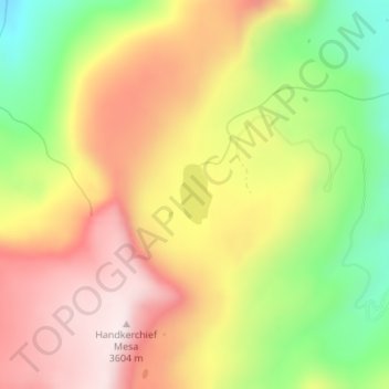
Nombre: Mapa topográfico Poage Lake, altitud, relieve.
Lugar: Poage Lake, Rio Grande County, Colorado, United States (37.49747 -106.64449 37.50166 -106.64166)
Altitud media: 3.369 m
Altitud mínima: 3.094 m
Altitud máxima: 3.607 m
Gracias por apoyar a este sitio ❤️
Haz una donación
Haz una donación
Otros mapas topográficos
Haga clic en un mapa para ver su topografía, su altitud y su relieve.
Del Norte
United States > Colorado > Rio Grande County
Relatively-speaking, it is located where the Rio Grande leaves the San Juan Mountains and enters the San Luis Valley, near its confluences with Pinos Creek and San Francisco Creek, respectively. Due to its location on the western edge of the valley, a variety of climates, vegetation regions, and ecosystems…
Altitud media: 2.416 m
Gracias por apoyar a este sitio ❤️
Haz una donación
Haz una donación