
Haz una donación
Mapa topográfico Crater Peak
Haga clic en el mapa para ver la altitud.
Haz una donación
Acerca de este mapa
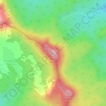
Nombre: Mapa topográfico Crater Peak, altitud, relieve.
Lugar: Crater Peak, Delta County, Colorado, United States (39.03966 -107.66316 39.03976 -107.66306)
Altitud media: 3.236 m
Altitud mínima: 3.092 m
Altitud máxima: 3.443 m
Haz una donación
Otros mapas topográficos
Haga clic en un mapa para ver su topografía, su altitud y su relieve.
Cedaredge
United States > Colorado > Delta County
Located in a protected valley at 6,100 feet (1,900 m) in elevation, the Cedaredge Golf Club course has natural cedars and winding creek beds.
Altitud media: 1.883 m
Haz una donación
Cedaredge
United States > Colorado > Delta County
Located in a protected valley at 6,100 feet (1,900 m) in elevation, the Cedaredge Golf Club course has natural cedars and winding creek beds.
Altitud media: 1.883 m
Cedaredge
United States > Colorado > Delta County
Located in a protected valley at 6,100 feet (1,900 m) in elevation, the Cedaredge Golf Club course has natural cedars and winding creek beds.
Altitud media: 1.883 m
Cedaredge
United States > Colorado > Delta County
Located in a protected valley at 6,100 feet (1,900 m) in elevation, the Cedaredge Golf Club course has natural cedars and winding creek beds.
Altitud media: 1.883 m
Haz una donación