
Mapa topográfico Plage des Porquerollais
Mapa interactivo
Haga clic en el mapa para ver la altitud.
Acerca de este mapa
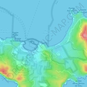
Nombre: Mapa topográfico Plage des Porquerollais, altitud, relieve.
Altitud media: 16 m
Altitud mínima: -1 m
Altitud máxima: 108 m
Otros mapas topográficos
Haga clic en un mapa para ver su topografía, su altitud y su relieve.
Hyères
France > Provence-Alpes-Côte d'Azur > Hyères
Hyères, Chemin des Falaises, Porquerolles, Hyères, Toulon, Var, Provence-Alpes-Côte d'Azur, France métropolitaine, 83400, France
Altitud media: 59 m
Îlot de la Gabinière
France > Provence-Alpes-Côte d'Azur > Hyères
Îlot de la Gabinière, Hyères, Toulon, Var, Provence-Alpes-Côte d'Azur, France métropolitaine, 83400, France
Altitud media: 20 m
Lac (artificiel) de Sainte-Eulalie
France > Provence-Alpes-Côte d'Azur > Hyères
Lac (artificiel) de Sainte-Eulalie, Chemin Des Maures, Hyères, Toulon, Var, Provence-Alpes-Côte d'Azur, France métropolitaine, 83400, France
Altitud media: 62 m
Plage des Salins
France > Provence-Alpes-Côte d'Azur > Hyères
Plage des Salins, Boulevard Eole, Hyères, Toulon, Var, Provence-Alpes-Côte d'Azur, France métropolitaine, 83400, France
Altitud media: 1 m
Île Longue
France > Provence-Alpes-Côte d'Azur > Hyères
Île Longue, Hyères, Toulon, Var, Provence-Alpes-Côte d'Azur, France métropolitaine, 83400, France
Altitud media: 7 m
Île de Bagaud
France > Provence-Alpes-Côte d'Azur > Hyères
Île de Bagaud, Hyères, Toulon, Var, Provence-Alpes-Côte d'Azur, France métropolitaine, 83400, France
Altitud media: 5 m