
Mapa topográfico La Puisaye
Mapa interactivo
Haga clic en el mapa para ver la altitud.
Acerca de este mapa
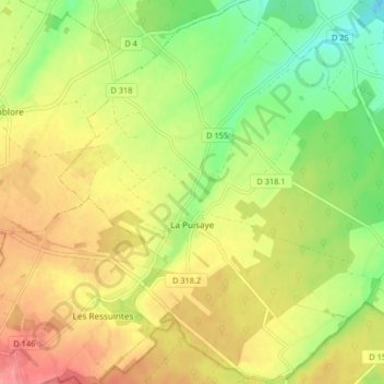
Nombre: Mapa topográfico La Puisaye, altitud, relieve.
Altitud media: 231 m
Altitud mínima: 190 m
Altitud máxima: 270 m
Otros mapas topográficos
Haga clic en un mapa para ver su topografía, su altitud y su relieve.
Sorel-Moussel
France > Centre-Val de Loire > Eure-et-Loir
Sorel-Moussel, Dreux, Eure-et-Loir, Centre-Val de Loire, France métropolitaine, 28260, France
Altitud media: 106 m
Chartres
France > Centre-Val de Loire > Eure-et-Loir
Chartres, Eure-et-Loir, Centre-Val de Loire, France métropolitaine, 28000, France
Altitud media: 150 m
Nogent-le-Phaye
France > Centre-Val de Loire > Eure-et-Loir
Nogent-le-Phaye, Chartres, Eure-et-Loir, Centre-Val de Loire, France métropolitaine, 28630, France
Altitud media: 144 m
Crécy-Couvé
France > Centre-Val de Loire > Eure-et-Loir
Crécy-Couvé, Dreux, Eure-et-Loir, Centre-Val de Loire, France métropolitaine, 28500, France
Altitud media: 152 m
Charpont
France > Centre-Val de Loire > Eure-et-Loir
Charpont, Dreux, Eure-et-Loir, Centre-Val de Loire, France métropolitaine, 28500, France
Altitud media: 111 m
Digny
France > Centre-Val de Loire > Eure-et-Loir
Digny, Dreux, Eure-et-Loir, Centre-Val de Loire, France métropolitaine, 28250, France
Altitud media: 221 m
Luray
France > Centre-Val de Loire > Eure-et-Loir
Luray, Dreux, Eure-et-Loir, Centre-Val de Loire, France métropolitaine, 28500, France
Altitud media: 125 m
Garnay
France > Centre-Val de Loire > Eure-et-Loir
Garnay, Dreux, Eure-et-Loir, Centre-Val de Loire, France métropolitaine, 28500, France
Altitud media: 130 m
Garancières-en-Drouais
France > Centre-Val de Loire > Eure-et-Loir
Garancières-en-Drouais, Dreux, Eure-et-Loir, Centre-Val de Loire, France métropolitaine, 28500, France
Altitud media: 146 m
Le Boullay-Mivoye
France > Centre-Val de Loire > Eure-et-Loir
Le Boullay-Mivoye, Dreux, Eure-et-Loir, Centre-Val de Loire, France métropolitaine, 28210, France
Altitud media: 142 m
Écluzelles
France > Centre-Val de Loire > Eure-et-Loir
Écluzelles, Dreux, Eure-et-Loir, Centre-Val de Loire, France métropolitaine, 28500, France
Altitud media: 106 m
Sainte-Gemme-Moronval
France > Centre-Val de Loire > Eure-et-Loir
Sainte-Gemme-Moronval, Dreux, Eure-et-Loir, Centre-Val de Loire, France métropolitaine, 28500, France
Altitud media: 105 m
Marville-Moutiers-Brûlé
France > Centre-Val de Loire > Eure-et-Loir
Marville-Moutiers-Brûlé, Dreux, Eure-et-Loir, Centre-Val de Loire, France métropolitaine, 28500, France
Altitud media: 135 m
Louvilliers-en-Drouais
France > Centre-Val de Loire > Eure-et-Loir
Louvilliers-en-Drouais, Dreux, Eure-et-Loir, Centre-Val de Loire, France métropolitaine, 28500, France
Altitud media: 139 m
Boissy-en-Drouais
France > Centre-Val de Loire > Eure-et-Loir
Boissy-en-Drouais, Dreux, Eure-et-Loir, Centre-Val de Loire, France métropolitaine, 28500, France
Altitud media: 143 m
Aunay-sous-Crécy
France > Centre-Val de Loire > Eure-et-Loir
Aunay-sous-Crécy, Dreux, Eure-et-Loir, Centre-Val de Loire, France métropolitaine, 28500, France
Altitud media: 146 m
Fresnay-le-Gilmert
France > Centre-Val de Loire > Eure-et-Loir
Fresnay-le-Gilmert, Chartres, Eure-et-Loir, Centre-Val de Loire, France métropolitaine, 28300, France
Altitud media: 162 m
Saint-Lubin-de-la-Haye
France > Centre-Val de Loire > Eure-et-Loir
Saint-Lubin-de-la-Haye, Dreux, Eure-et-Loir, Centre-Val de Loire, France métropolitaine, 28410, France
Altitud media: 115 m
Saint-Bomer
France > Centre-Val de Loire > Eure-et-Loir
Saint-Bomer, Nogent-le-Rotrou, Eure-et-Loir, Centre-Val de Loire, France métropolitaine, 28330, France
Altitud media: 206 m
Bû
France > Centre-Val de Loire > Eure-et-Loir
Bû, Dreux, Eure-et-Loir, Centre-Val de Loire, France métropolitaine, 28410, France
Altitud media: 129 m
Lèves
France > Centre-Val de Loire > Eure-et-Loir
Lèves, Chartres, Eure-et-Loir, Centre-Val de Loire, France métropolitaine, 28300, France
Altitud media: 151 m
La Giraudière
France > Centre-Val de Loire > Eure-et-Loir > Unverre
La Giraudière, Unverre, Châteaudun, Eure-et-Loir, Centre-Val de Loire, France métropolitaine, 28160, France
Altitud media: 174 m
Montigny-le-Chartif
France > Centre-Val de Loire > Eure-et-Loir
Montigny-le-Chartif, Nogent-le-Rotrou, Eure-et-Loir, Centre-Val de Loire, France métropolitaine, 28120, France
Altitud media: 187 m
Saint-Victor-de-Buthon
France > Centre-Val de Loire > Eure-et-Loir
Saint-Victor-de-Buthon, Nogent-le-Rotrou, Eure-et-Loir, Centre-Val de Loire, France métropolitaine, 28240, France
Altitud media: 221 m
Saint-Denis-les-Ponts
France > Centre-Val de Loire > Eure-et-Loir > Saint-Denis-Lanneray
Saint-Denis-les-Ponts, Saint-Denis-Lanneray, Châteaudun, Eure-et-Loir, Centre-Val de Loire, France métropolitaine, 28200, France
Altitud media: 132 m
Trizay-Coutretot-Saint-Serge
France > Centre-Val de Loire > Eure-et-Loir
Trizay-Coutretot-Saint-Serge, Nogent-le-Rotrou, Eure-et-Loir, Centre-Val de Loire, France métropolitaine, 28400, France
Altitud media: 173 m
Frétigny
France > Centre-Val de Loire > Eure-et-Loir > Saintigny
Frétigny, Saintigny, Nogent-le-Rotrou, Eure-et-Loir, Centre-Val de Loire, France métropolitaine, 28480, France
Altitud media: 246 m
Vichères
France > Centre-Val de Loire > Eure-et-Loir
Vichères, Nogent-le-Rotrou, Eure-et-Loir, Centre-Val de Loire, France métropolitaine, 28480, France
Altitud media: 221 m
Cherisy
France > Centre-Val de Loire > Eure-et-Loir
Cherisy, Dreux, Eure-et-Loir, Centre-Val de Loire, France métropolitaine, 28500, France
Altitud media: 115 m
Le Cornet
France > Centre-Val de Loire > Eure-et-Loir > Saint-Lubin-de-la-Haye
Le Cornet, Saint-Lubin-de-la-Haye, Dreux, Eure-et-Loir, Centre-Val de Loire, France métropolitaine, 28410, France
Altitud media: 126 m
Gas
France > Centre-Val de Loire > Eure-et-Loir
Gas, Chartres, Eure-et-Loir, Centre-Val de Loire, France métropolitaine, 28320, France
Altitud media: 145 m
Cherville
France > Centre-Val de Loire > Eure-et-Loir > Villemeux-sur-Eure
Cherville, Villemeux-sur-Eure, Dreux, Eure-et-Loir, Centre-Val de Loire, France métropolitaine, 28210, France
Altitud media: 134 m
La Tesserie
France > Centre-Val de Loire > Eure-et-Loir > Charbonnières
La Tesserie, Charbonnières, Nogent-le-Rotrou, Eure-et-Loir, Centre-Val de Loire, France métropolitaine, 28330, France
Altitud media: 214 m
Bullou
France > Centre-Val de Loire > Eure-et-Loir > Dangeau
Bullou, Dangeau, Châteaudun, Eure-et-Loir, Centre-Val de Loire, France métropolitaine, 28160, France
Altitud media: 157 m
Saint-Rémy-sur-Avre
France > Centre-Val de Loire > Eure-et-Loir
Saint-Rémy-sur-Avre, Dreux, Eure-et-Loir, Centre-Val de Loire, France métropolitaine, 28380, France
Altitud media: 132 m
Bourg Neuf
France > Centre-Val de Loire > Eure-et-Loir > La Ferté-Vidame
Bourg Neuf, La Ferté-Vidame, Dreux, Eure-et-Loir, Centre-Val de Loire, France métropolitaine, 28340, France
Altitud media: 260 m
Rueil-la-Gadelière
France > Centre-Val de Loire > Eure-et-Loir
Rueil-la-Gadelière, Dreux, Eure-et-Loir, Centre-Val de Loire, France métropolitaine, 28270, France
Altitud media: 176 m
La Ferté-Vidame
France > Centre-Val de Loire > Eure-et-Loir
La Ferté-Vidame, Dreux, Eure-et-Loir, Centre-Val de Loire, France métropolitaine, 28340, France
Altitud media: 247 m
Le Barc
France > Centre-Val de Loire > Eure-et-Loir > Unverre
Le Barc, Unverre, Châteaudun, Eure-et-Loir, Centre-Val de Loire, France métropolitaine, 28160, France
Altitud media: 172 m
Berchères-sur-Vesgre
France > Centre-Val de Loire > Eure-et-Loir
Berchères-sur-Vesgre, Dreux, Eure-et-Loir, Centre-Val de Loire, France métropolitaine, 28260, France
Altitud media: 117 m
Gommiers
France > Centre-Val de Loire > Eure-et-Loir > Terminiers
Gommiers, Terminiers, Châteaudun, Eure-et-Loir, Centre-Val de Loire, France métropolitaine, 28140, France
Altitud media: 131 m
Merangle
France > Centre-Val de Loire > Eure-et-Loir > La Chapelle-Forainvilliers
Merangle, La Chapelle-Forainvilliers, Dreux, Eure-et-Loir, Centre-Val de Loire, France métropolitaine, 28500, France
Altitud media: 130 m
Langey
France > Centre-Val de Loire > Eure-et-Loir > Vald'Yerre
Langey, Vald'Yerre, Châteaudun, Eure-et-Loir, Centre-Val de Loire, France métropolitaine, 28220, France
Altitud media: 146 m
Manou
France > Centre-Val de Loire > Eure-et-Loir
Manou, Nogent-le-Rotrou, Eure-et-Loir, Centre-Val de Loire, France métropolitaine, 28240, France
Altitud media: 242 m
Pontgouin
France > Centre-Val de Loire > Eure-et-Loir
Pontgouin, Chartres, Eure-et-Loir, Centre-Val de Loire, France métropolitaine, 28190, France
Altitud media: 210 m
La Touchardière
France > Centre-Val de Loire > Eure-et-Loir > Charbonnières
La Touchardière, Charbonnières, Nogent-le-Rotrou, Eure-et-Loir, Centre-Val de Loire, France métropolitaine, 28330, France
Altitud media: 224 m
Chappe
France > Centre-Val de Loire > Eure-et-Loir > Saint-Maixme-Hauterive
Chappe, Saint-Maixme-Hauterive, Dreux, Eure-et-Loir, Centre-Val de Loire, France métropolitaine, 28170, France
Altitud media: 207 m
La Framboisière
France > Centre-Val de Loire > Eure-et-Loir
La Framboisière, Dreux, Eure-et-Loir, Centre-Val de Loire, France métropolitaine, 28250, France
Altitud media: 217 m
Ymonville
France > Centre-Val de Loire > Eure-et-Loir
Ymonville, Chartres, Eure-et-Loir, Centre-Val de Loire, France métropolitaine, 28150, France
Altitud media: 139 m
Sours
France > Centre-Val de Loire > Eure-et-Loir
Sours, Chartres, Eure-et-Loir, Centre-Val de Loire, France métropolitaine, 28630, France
Altitud media: 151 m