
Mapa topográfico Throwley
Mapa interactivo
Haga clic en el mapa para ver la altitud.
Acerca de este mapa
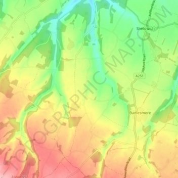
Nombre: Mapa topográfico Throwley, altitud, relieve.
Lugar: Throwley, Borough of Swale, Kent, England, United Kingdom (51.23070 0.82195 51.28564 0.87928)
Altitud media: 96 m
Altitud mínima: 32 m
Altitud máxima: 164 m
Otros mapas topográficos
Haga clic en un mapa para ver su topografía, su altitud y su relieve.
Sittingbourne
United Kingdom > England > Kent > Borough of Swale
Sittingbourne, Borough of Swale, Kent, England, ME10 4AL, United Kingdom
Altitud media: 37 m
Oare Creek
United Kingdom > England > Kent > Borough of Swale > Faversham > Oare
Oare Creek, Faversham, Oare, Borough of Swale, Kent, England, ME13 7TU, United Kingdom
Altitud media: 6 m
Norton
United Kingdom > England > Kent > Borough of Swale
Norton, Borough of Swale, Kent, England, ME9 9JU, United Kingdom
Altitud media: 35 m
Seed
United Kingdom > England > Kent > Borough of Swale > Doddington
Seed, Newnham, Doddington, Borough of Swale, Kent, England, ME9 0NE, United Kingdom
Altitud media: 101 m
Boughton under Blean
United Kingdom > England > Kent > Borough of Swale
Boughton under Blean, Borough of Swale, Kent, England, United Kingdom
Altitud media: 48 m
Graveney
United Kingdom > England > Kent > Borough of Swale
Graveney, Borough of Swale, Kent, England, ME13 9DZ, United Kingdom
Altitud media: 8 m
Isle of Sheppey
United Kingdom > England > Kent > Borough of Swale
Isle of Sheppey, Borough of Swale, Kent, England, United Kingdom
Altitud media: 6 m
Upchurch
United Kingdom > England > Kent > Borough of Swale
Upchurch, Borough of Swale, Kent, England, United Kingdom
Altitud media: 10 m
Halfway
United Kingdom > England > Kent > Borough of Swale
Halfway, Borough of Swale, Kent, England, ME12 3BZ, United Kingdom
Altitud media: 6 m
Iwade
United Kingdom > England > Kent > Borough of Swale
Iwade, Borough of Swale, Kent, England, United Kingdom
Altitud media: 6 m
Hickmans Green
United Kingdom > England > Kent > Borough of Swale > Boughton Street
Hickmans Green, Boughton under Blean, Boughton Street, Borough of Swale, Kent, England, ME13 9NT, United Kingdom
Altitud media: 63 m
Great Norwood
United Kingdom > England > Kent > Borough of Swale > Bobbing
Great Norwood, Bobbing, Borough of Swale, Kent, England, ME9 8QB, United Kingdom
Altitud media: 27 m
Ham Green
United Kingdom > England > Kent > Borough of Swale > Upchurch
Ham Green, Upchurch, Borough of Swale, Kent, England, ME9 7HH, United Kingdom
Altitud media: 4 m
Bapchild
United Kingdom > England > Kent > Borough of Swale > Bapchild
Bapchild, Borough of Swale, Kent, England, United Kingdom
Altitud media: 21 m
Faversham
United Kingdom > England > Kent > Borough of Swale > Ospringe
Faversham, Ospringe, Borough of Swale, Kent, England, United Kingdom
Altitud media: 17 m
Oversland
United Kingdom > England > Kent > Borough of Swale
Oversland, Borough of Swale, Kent, England, ME13 9PE, United Kingdom
Altitud media: 73 m
Whitehill
United Kingdom > England > Kent > Borough of Swale > Painter's Forstal
Whitehill, Ospringe, Painter's Forstal, Borough of Swale, Kent, England, ME13 0DN, United Kingdom
Altitud media: 45 m
Rodmersham Green
United Kingdom > England > Kent > Borough of Swale > Rodmersham Green
Rodmersham Green, Borough of Swale, Kent, England, ME9 0PT, United Kingdom
Altitud media: 48 m
Dargate
United Kingdom > England > Kent > Borough of Swale
Dargate, Borough of Swale, Kent, England, ME13 9HH, United Kingdom
Altitud media: 40 m
Faversham Creek
United Kingdom > England > Kent > Borough of Swale > Faversham > Oare
Faversham Creek, The Brents, Faversham, Oare, Borough of Swale, Kent, England, ME13 7LD, United Kingdom
Altitud media: 11 m
Doddington
United Kingdom > England > Kent > Borough of Swale
Doddington, Borough of Swale, Kent, England, United Kingdom
Altitud media: 103 m
Teynham
United Kingdom > England > Kent > Borough of Swale
Teynham, Borough of Swale, Kent, England, United Kingdom
Altitud media: 6 m
Bredgar
United Kingdom > England > Kent > Borough of Swale
Bredgar, Borough of Swale, Kent, England, United Kingdom
Altitud media: 100 m
Lewson Street
United Kingdom > England > Kent > Borough of Swale > Norton
Lewson Street, Norton, Borough of Swale, Kent, England, United Kingdom
Altitud media: 36 m
Queenborough
United Kingdom > England > Kent > Borough of Swale
Queenborough, Borough of Swale, Kent, England, United Kingdom
Altitud media: 2 m
Sheerness
United Kingdom > England > Kent > Borough of Swale
Sheerness, Borough of Swale, Kent, England, United Kingdom
Altitud media: 3 m
Oare
United Kingdom > England > Kent > Borough of Swale
Oare, Borough of Swale, Kent, England, United Kingdom
Altitud media: 4 m
Hartlip
United Kingdom > England > Kent > Borough of Swale
Hartlip, Borough of Swale, Kent, England, United Kingdom
Altitud media: 69 m
Tonge
United Kingdom > England > Kent > Borough of Swale > Bapchild
Tonge, Bapchild, Borough of Swale, Kent, England, United Kingdom
Altitud media: 23 m
Ospringe
United Kingdom > England > Kent > Borough of Swale
Ospringe, Borough of Swale, Kent, England, United Kingdom
Altitud media: 51 m
Dunkirk
United Kingdom > England > Kent > Borough of Swale
Dunkirk, Borough of Swale, Kent, England, ME13 9LF, United Kingdom
Altitud media: 74 m
Minster
United Kingdom > England > Kent > Borough of Swale
Minster, Borough of Swale, Kent, England, ME12 3QD, United Kingdom
Altitud media: 9 m
Uplees
United Kingdom > England > Kent > Borough of Swale
Uplees, Oare, Borough of Swale, Kent, England, ME13 0QR, United Kingdom
Altitud media: 5 m
Sheldwich Lees
United Kingdom > England > Kent > Borough of Swale > Sheldwich
Sheldwich Lees, Sheldwich, Borough of Swale, Kent, England, ME13 0ED, United Kingdom
Altitud media: 75 m