
Mapa topográfico Pine Knot
Mapa interactivo
Haga clic en el mapa para ver la altitud.
Acerca de este mapa
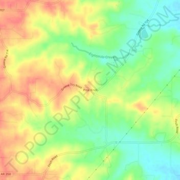
Nombre: Mapa topográfico Pine Knot, altitud, relieve.
Lugar: Pine Knot, Greene County, Arkansas, United States (36.00840 -90.61789 36.04840 -90.57789)
Altitud media: 131 m
Altitud mínima: 100 m
Altitud máxima: 159 m
Otros mapas topográficos
Haga clic en un mapa para ver su topografía, su altitud y su relieve.
Marmaduke
United States > Arkansas > Greene County
Marmaduke, Greene County, Arkansas, 72443, United States
Altitud media: 87 m
Crowleys Ridge State Park
United States > Arkansas > Greene County > Walcott
Crowleys Ridge State Park, Walcott, Greene County, Arkansas, United States
Altitud media: 108 m
Paragould
United States > Arkansas > Greene County
Paragould, Greene County, Arkansas, United States
Altitud media: 91 m