
Mapa topográfico West Ghent
Mapa interactivo
Haga clic en el mapa para ver la altitud.
Acerca de este mapa
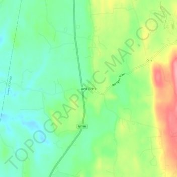
Nombre: Mapa topográfico West Ghent, altitud, relieve.
Altitud media: 72 m
Altitud mínima: 32 m
Altitud máxima: 141 m
Otros mapas topográficos
Haga clic en un mapa para ver su topografía, su altitud y su relieve.
Pulvers
United States > New York > Columbia County > Town of Ghent
Pulvers, Town of Ghent, Columbia County, New York, 12075, United States
Altitud media: 111 m
Arnolds Mill
United States > New York > Columbia County > Town of Ghent
Arnolds Mill, Town of Ghent, Columbia County, New York, 12037, United States
Altitud media: 178 m
Omi
United States > New York > Columbia County > Town of Ghent
Omi, Town of Ghent, Columbia County, New York, 12075, United States
Altitud media: 93 m
Buckleyville
United States > New York > Columbia County > Town of Ghent
Buckleyville, Town of Ghent, Columbia County, New York, 12037, United States
Altitud media: 157 m