
Haz una donación
Mapa topográfico Utah Lake
Haga clic en el mapa para ver la altitud.
Haz una donación
Utah Lake
Utah Lake is a shallow freshwater lake in the center of Utah County, Utah, United States. It lies in Utah Valley, surrounded by the Provo-Orem metropolitan area. The lake's only river outlet, the Jordan River, is a tributary of the Great Salt Lake. Evaporation accounts for 42% of the lake's outflow, which leaves the lake slightly saline. The elevation of the lake is at 4,489 feet (1,368 m) above sea level. If the lake's water level rises above that, the pumps and gates on the Jordan River are left open. Recently the lake has been at a lower level because of a drought.
Haz una donación
Acerca de este mapa
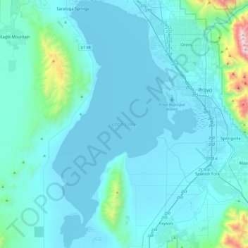
Nombre: Mapa topográfico Utah Lake, altitud, relieve.
Lugar: Utah Lake, Utah County, Utah, 84045, United States (40.00922 -111.94295 40.36121 -111.67254)
Altitud media: 1.512 m
Altitud mínima: 1.364 m
Altitud máxima: 3.293 m
Haz una donación