
Mapa topográfico Stapleford
Mapa interactivo
Haga clic en el mapa para ver la altitud.
Acerca de este mapa
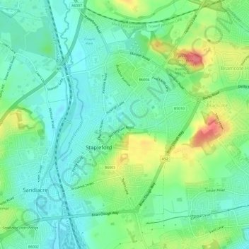
Nombre: Mapa topográfico Stapleford, altitud, relieve.
Lugar: Stapleford, Broxtowe, Nottinghamshire, England, United Kingdom (52.91477 -1.28580 52.95054 -1.25082)
Altitud media: 55 m
Altitud mínima: 33 m
Altitud máxima: 102 m
Otros mapas topográficos
Haga clic en un mapa para ver su topografía, su altitud y su relieve.
Beeston
United Kingdom > England > Nottinghamshire > Broxtowe
Beeston, Broxtowe, Nottinghamshire, England, NG9 2JJ, United Kingdom
Altitud media: 44 m
Manor House Pond
United Kingdom > England > Nottinghamshire > Broxtowe > Bramcote
Manor House Pond, Bramcote Hills, Bramcote, Broxtowe, Nottinghamshire, England, United Kingdom
Altitud media: 57 m
Beeston
United Kingdom > England > Nottinghamshire > Broxtowe
Beeston, Broxtowe, Nottinghamshire, England, United Kingdom
Altitud media: 39 m
Nottingham Canal
United Kingdom > England > Nottinghamshire > Broxtowe
Nottingham Canal, Cossall Marsh, Broxtowe, Nottinghamshire, England, NG16 2RU, United Kingdom
Altitud media: 68 m
Attenborough Nature Reserve
United Kingdom > England > Nottinghamshire > Broxtowe
Attenborough Nature Reserve, Tissington Close, Chilwell Meadows Business Park, Chilwell, Broxtowe, Nottinghamshire, England, NG9 6QG, United Kingdom
Altitud media: 34 m
Kimberley
United Kingdom > England > Nottinghamshire > Broxtowe
Kimberley, Broxtowe, Nottinghamshire, England, United Kingdom
Altitud media: 104 m
Cossall
United Kingdom > England > Nottinghamshire > Broxtowe
Cossall, Broxtowe, Nottinghamshire, England, United Kingdom
Altitud media: 70 m
Strelley
United Kingdom > England > Nottinghamshire > Broxtowe > Strelley
Strelley, Broxtowe, Nottinghamshire, East Midlands, England, United Kingdom
Altitud media: 100 m
Nuthall
United Kingdom > England > Nottinghamshire > Broxtowe
Nuthall, Broxtowe, Nottinghamshire, England, United Kingdom
Altitud media: 95 m
Nottingham Canal Local Nature Reserve
United Kingdom > England > Nottinghamshire > Broxtowe
Nottingham Canal Local Nature Reserve, Moor Lane, Bramcote Hills, Broxtowe, Nottinghamshire, East Midlands, England, NG9 3GP, United Kingdom
Altitud media: 66 m
Giltbrook
United Kingdom > England > Nottinghamshire > Broxtowe
Giltbrook, Broxtowe, Nottinghamshire, England, NG16 2WJ, United Kingdom
Altitud media: 86 m
Stapleford
United Kingdom > England > Nottinghamshire > Broxtowe
Stapleford, Broxtowe, Nottinghamshire, England, United Kingdom
Altitud media: 54 m
Greasley
United Kingdom > England > Nottinghamshire > Broxtowe
Greasley, Broxtowe, Nottinghamshire, England, United Kingdom
Altitud media: 104 m
Eastwood CP
United Kingdom > England > Nottinghamshire > Broxtowe
Eastwood CP, Broxtowe, Nottinghamshire, England, United Kingdom
Altitud media: 81 m
Newthorpe
United Kingdom > England > Nottinghamshire > Broxtowe
Newthorpe, Broxtowe, Nottinghamshire, England, NG16 2AS, United Kingdom
Altitud media: 85 m