
Mapa topográfico Cleeve Hill
Mapa interactivo
Haga clic en el mapa para ver la altitud.
Acerca de este mapa
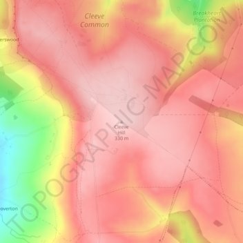
Nombre: Mapa topográfico Cleeve Hill, altitud, relieve.
Altitud media: 272 m
Altitud mínima: 119 m
Altitud máxima: 330 m
Otros mapas topográficos
Haga clic en un mapa para ver su topografía, su altitud y su relieve.
Charlton Abbots
United Kingdom > England > Gloucestershire > Tewkesbury
Charlton Abbots, Tewkesbury, Gloucestershire, England, GL54 5TF, United Kingdom
Altitud media: 227 m
Wormington
United Kingdom > England > Gloucestershire > Tewkesbury
Wormington, Tewkesbury, Gloucestershire, England, WR12 7NL, United Kingdom
Altitud media: 56 m
Alderton
United Kingdom > England > Gloucestershire > Tewkesbury
Alderton, Tewkesbury, Gloucestershire, England, GL20 8NZ, United Kingdom
Altitud media: 68 m
Leigh
United Kingdom > England > Gloucestershire > Tewkesbury
Leigh, Tewkesbury, Gloucestershire, England, GL19 4AG, United Kingdom
Altitud media: 17 m
Coopers Hill Wood
United Kingdom > England > Gloucestershire > Tewkesbury > Cooper's Hill
Coopers Hill Wood, Cooper's Hill, Brockworth, Tewkesbury, Gloucestershire, England, United Kingdom
Altitud media: 157 m
Winchcombe
United Kingdom > England > Gloucestershire > Tewkesbury > Winchcombe
Winchcombe, Tewkesbury, Gloucestershire, England, United Kingdom
Altitud media: 157 m