
Haz una donación
Mapa topográfico Oberzerf
Haga clic en el mapa para ver la altitud.
Haz una donación
Acerca de este mapa
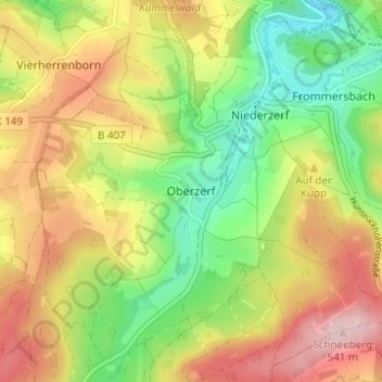
Nombre: Mapa topográfico Oberzerf, altitud, relieve.
Altitud media: 439 m
Altitud mínima: 334 m
Altitud máxima: 559 m
Haz una donación
Otros mapas topográficos
Haga clic en un mapa para ver su topografía, su altitud y su relieve.
Konz
Deutschland > Rheinland-Pfalz > Landkreis Trier-Saarburg
Contionacum war der Name einer spätrömischen Kaiservilla (die Kaiservilla von Konz), deren Reste ergraben sind und die auch in antiken Quellen genannt wird. Besondere geschichtliche Bedeutung erlangte die am 11. August 1675 bei Konz ausgefochtene Schlacht an der Konzer Brücke während des Holländischen…
Altitud media: 232 m
Mehring
Deutschland > Rheinland-Pfalz > Landkreis Trier-Saarburg
Beim Dorfbrand von 1840 wurden 156 von 222 Gebäuden zerstört. Im Zuge des Wiederaufbaues entstand rechts der Mosel auf der Höhe die Kolonie Neu-Mehring.
Altitud media: 285 m
Neuhütten
Deutschland > Rheinland-Pfalz > Landkreis Trier-Saarburg
Am 10. März 1966 ging im Wald beim Forsthaus Neuhof nur fünf Jahre nach seiner Indienststellung der 50. Starfighter der Bundeswehr verloren. Am Morgen war der 28-jährige Pilot Feldwebel Horst Stüber mit seiner F 104 „Starfighter“ beim Fliegerhorst des Jagdbombergeschwaders 33 in Büchel/Eifel zu einem…
Altitud media: 602 m
Haz una donación
Züsch
Deutschland > Rheinland-Pfalz > Landkreis Trier-Saarburg
Zu Züsch gehören auch die Wohnplätze Birkenau, Hochwaldhof, Retzenhöhe und Rosenhof.
Altitud media: 575 m
Haz una donación
Hermeskeil
Deutschland > Rheinland-Pfalz > Landkreis Trier-Saarburg
Die Stadt liegt im Schwarzwälder Hochwald im Südwesten des Hunsrücks. Die Gemarkung erstreckt sich in 500 bis 600 Metern Höhe in einer Mulde des Hochwalds, die den geographischen Mittelpunkt des Naturparks Saar-Hunsrück bildet. Eine Nachbarstadt ist das saarländische Wadern. Hermeskeil liegt an den…
Altitud media: 540 m
Saarburg
Deutschland > Rheinland-Pfalz > Landkreis Trier-Saarburg
Das Landschaftsbild ist abwechslungsreich. Insbesondere der Verlauf der Saar zeichnet sich durch steil abfallende Berghänge, tief eingeschnittene Täler und lang gezogene Umlaufberge aus. Weinberge prägen das Ortsbild der für den Saarwein bekannten Region. Der Schloßberg hat eine Höhe von 206,5 m ü. NHN.…
Altitud media: 268 m
Schweich
Deutschland > Rheinland-Pfalz > Landkreis Trier-Saarburg
Schweich bezeichnet das Messtischblatt Nr. 6106 (früher Nr. 3456) der topografischen Karte im Maßstab 1:25.000.
Altitud media: 241 m
Haz una donación
Reinsfeld
Deutschland > Rheinland-Pfalz > Landkreis Trier-Saarburg
Reinsfeld hat Anbindungen zur Hunsrückhöhenstraße B407, zur Bundesautobahn 1 (mit den Autobahnraststätten „Hochwald West“ und „Hochwald Ost“) und zur Landesstraße 151.
Altitud media: 542 m
Kell am See
Deutschland > Rheinland-Pfalz > Landkreis Trier-Saarburg
Kell am See an der Hunsrückhöhenstraße ist eine Ortsgemeinde im Landkreis Trier-Saarburg in Rheinland-Pfalz. Sie gehört der Verbandsgemeinde Saarburg-Kell an, die dort einen weiteren Verwaltungssitz hat. Kell am See ist ein staatlich anerkannter Luftkurort und gemäß Landesplanung als Grundzentrum ausgewiesen.
Altitud media: 521 m
Haz una donación
Palzem
Deutschland > Rheinland-Pfalz > Landkreis Trier-Saarburg
Auf einer Moselanhöhe im Ortsteil Kreuzweiler erhebt sich das Schloss Thorn. Der Name stammt vom Lateinischen turis (= Turm). Dieser wurde vor ungefähr 2000 Jahren zum Schutz einer Furt als Moselübergang errichtet. Die Burg wurde im 13. Jahrhundert erbaut. Bauliche Erweiterungen im 16. und 17. Jahrhundert…
Altitud media: 206 m
Zerf
Deutschland > Rheinland-Pfalz > Landkreis Trier-Saarburg
Zerf liegt am Großbach und an der Ruwer im Naturpark Saar-Hunsrück in waldreicher Höhenlage. Bei Zerf verläuft der Ruwer-Hochwald-Radweg auf der Trasse der ehemaligen Hochwaldbahn.
Altitud media: 471 m
Haz una donación
Osburg
Deutschland > Rheinland-Pfalz > Landkreis Trier-Saarburg
Das Klima des Ortes Osburg sowie des gesamten Osburger Hochwaldes als Teil des Hunsrück ist ozeanisch geprägt. Die Sommer sind recht kühl, die Winter -im Vergleich zu weiter östlich gelegenen Mittelgebirgen- eher mild, aber auf Grund der Höhenlage und häufiger Niederschläge im Winter, durchaus schneereich.
Altitud media: 465 m
Kasel
Deutschland > Rheinland-Pfalz > Landkreis Trier-Saarburg
Kasel liegt zwischen Mertesdorf und Waldrach im Ruwertal, umgeben von steil ansteigenden Weinbergen. Zum Ort gehört der Wohnplatz Benninger Hof, der auf der Höhe zwischen Kasel und Trier-Tarforst gelegen ist. Der Bereich um die heutige Bahnhofstraße gehörte bis 1929 zur Gemarkung Waldrach.
Altitud media: 270 m
Haz una donación
Sirzenich
Deutschland > Rheinland-Pfalz > Landkreis Trier-Saarburg
Die Ortschaft befindet sich in der Südeifel nahe der Grenze zu Luxemburg, die hier von der Sauer gebildet wird. Der Ort liegt erhöht über dem Tal des Sirzenicher Bachs, einem linken Zufluss der Mosel, auf einer Höhe von etwa 350 m ü. NHN im Ortszentrum und steigt bis 385 m ü. NHN auf der Aacher Höhe an.…
Altitud media: 316 m
Morscheid
Deutschland > Rheinland-Pfalz > Landkreis Trier-Saarburg
Der Ort liegt auf einem Höhenrücken des Osburger Hochwalds zwischen den Tälern von Ruwer und Riveris. Die dreiseitig abfallende und nach Norden am Zusammenfluss der Bäche abgerundete Schieferhochfläche verleiht Morscheid eine exponierte Lage. Stollen und Gruben weisen auf den ehemaligen Abbau von Schiefer…
Altitud media: 323 m
Haz una donación
Leiwen
Deutschland > Rheinland-Pfalz > Landkreis Trier-Saarburg
Leiwen ist Namensgeber der naturräumlichen Einheit Leiwener Moselrandhöhen. Ein Ortsteil von Leiwen ist die Leiwener Mühle im Dhrontal. Südöstlich des Ortes liegt auf der Höhe die Siedlung Zummeterhof. Nachbargemeinden sind Köwerich, Trittenheim, Heidenburg, Büdlich, Detzem und Thörnich.
Altitud media: 253 m
Haz una donación
Mertesdorf
Deutschland > Rheinland-Pfalz > Landkreis Trier-Saarburg
Die Geschichte des Dorfes reicht bis in die Römerzeit zurück. Die Römerstraße von Trier nach Mainz führte durch dieses Nebental auf die Hunsrückhöhen. Römische Baureste, ein römischer Friedhof nahe der heutigen Landesstraße 151, die nachgewiesene römische Gesteinsmühle im Tal sowie Zeugnisse des…
Altitud media: 264 m
Haz una donación
Waldrach
Deutschland > Rheinland-Pfalz > Landkreis Trier-Saarburg
Links der Ruwer liegt die markante Naumeter Kupp, die zu Trier-Tarforst gehört. Auf der anderen Talseite liegen die höchsten Erhebungen der Gemarkung mit dem Hochbüschkopf (408 m), Ginner (423 m), Biedelt (426 m) und dem Läusberg (427 m). Als Waldracher Berg bezeichnet man den Abschnitt der Landesstraße…
Altitud media: 301 m
Haz una donación
Korlingen
Deutschland > Rheinland-Pfalz > Landkreis Trier-Saarburg
Sehenswert ist die kleine Kapelle im Ortskern. Die Höhe über Korlingen (Schellberg) ist beliebt für Spaziergänge mit schöner Aussicht über die Trierer Höhenstadtteile Irsch, Filsch und Tarforst und über das Ruwertal zum Hunsrück. Im Winter kommen viele Trierer zum Rodeln, nicht nur im Herbst bieten…
Altitud media: 312 m
Irsch
Deutschland > Rheinland-Pfalz > Landkreis Trier-Saarburg
Die Gemeinde liegt östlich der Saar an der Hunsrückhöhenstraße im Naturpark Saar-Hunsrück.
Altitud media: 298 m
Haz una donación
Keller Stausee
Deutschland > Rheinland-Pfalz > Landkreis Trier-Saarburg > Kell am See
Altitud media: 493 m
Ruwer
Deutschland > Rheinland-Pfalz > Landkreis Trier-Saarburg
Die Verbandsgemeinde Ruwer liegt hauptsächlich im Bereich der naturräumlichen Landschaftseinheiten Unteres Ruwertal, Ruwerengtal, Osburger Hunsrück und Osburger Hochwald, teilweise auch im Bereich der Pellinger Hochflächen, dem Tarforster Plateau und der Leiwener Moselrandhöhen.
Altitud media: 409 m
Haz una donación
Kirsch
Deutschland > Rheinland-Pfalz > Landkreis Trier-Saarburg
Auf der Höhe des Kirscher Fährturmes befand sich bis 1974 das Gasthaus Valerius (Gasthaus zur Schweicher Fähre).
Altitud media: 175 m
Ayl
Deutschland > Rheinland-Pfalz > Landkreis Trier-Saarburg
Ayl liegt in einem Seitental der unteren Saar zwischen dem Mohlemskopf, einer 321 m hohen Anhöhe nördlich von Saarburg, und der Ayler Kupp, einer 251 m hohen Bergzunge mit der gleichnamigen Weinlage.
Altitud media: 210 m
Haz una donación
Fusenich
Deutschland > Rheinland-Pfalz > Landkreis Trier-Saarburg > Trierweiler
Fusenich liegt in der Südeifel nahe der Grenze zu Luxemburg, die hier der Sauer folgt. Die Ortschaft steht erhöht über dem Tal des Gelbachs, der über den Stegbach in die Sauer fließt, auf einer Höhe von etwa 289 Meter über NHN im Ortszentrum und steigt bis 375 Meter auf der Anhöhe Auf der First an.
Altitud media: 308 m
Schoden
Deutschland > Rheinland-Pfalz > Landkreis Trier-Saarburg
Die höchste Erhebung ist der Geisberg49.6287936.613802 mit einer Höhe von 482,1 m ü. NHN.
Altitud media: 216 m
Haz una donación
Fellerich
Deutschland > Rheinland-Pfalz > Landkreis Trier-Saarburg > Fellerich
Der Ort liegt auf einer Höhe von etwa 275 m ü. NHN und ist vorwiegend landwirtschaftlich durch Wein- und Ackerbau geprägt.
Altitud media: 290 m
Fell
Deutschland > Rheinland-Pfalz > Landkreis Trier-Saarburg
Durch Fell fließt der Feller Bach, der bei Riol in die Mosel mündet; auf dem Gemeindegebiet überspannt die Fellerbachtalbrücke sein unteres Tal in 100 Metern Höhe.
Altitud media: 291 m
Haz una donación
Ruwer
Deutschland > Rheinland-Pfalz > Landkreis Trier-Saarburg
Die Ruwer entspringt am Forstort Ruwerspring am Südhang des Rösterkopfs im Osburger Hochwald auf einer Höhe von etwa 650 m ü. NHN.
Altitud media: 376 m
Haz una donación
Panzbruch bei Greimerath
Deutschland > Rheinland-Pfalz > Landkreis Trier-Saarburg > Greimerath
Altitud media: 465 m
Haz una donación
Wasserliesch
Deutschland > Rheinland-Pfalz > Landkreis Trier-Saarburg
Die Gemeinde Wasserliesch bildet an der nordöstlichen Flanke des 347 m hohen Liescher Berges, der hier Löschemer Berg genannt wird, eine weite Hanglage. Als Ausläufer des zum Lothringer Stufenland gehörenden Saargaus, der sich links der Saar entlang der deutsch-französischen Grenze von Saarbrücken bis…
Altitud media: 199 m
Pellingen
Deutschland > Rheinland-Pfalz > Landkreis Trier-Saarburg
Nach der Eroberung des Treverer-Gebietes durch Julius Cäsar wurde auch über die Pellinger Höhen entlang eines vermutlich alten Keltenweges eine römische Heerstraße ausgebaut, die das römische Trier (Augusta Treverorum) mit den wichtigen Handelszentren Contiomagus (Dillingen-Pachten) und Teulegium…
Altitud media: 386 m
Söst
Deutschland > Rheinland-Pfalz > Landkreis Trier-Saarburg
Das Dorfgemeinschaftshaus wurde 1976 in Eigenleistung errichtet und 1989 erweitert. Die von der Dorfgemeinschaft auf einer Anhöhe errichtete Langheckhütte folgte 1996 und steht seitdem für Vereine und Veranstaltungen zur Verfügung.
Altitud media: 355 m
Haz una donación
Beuren (Hochwald)
Deutschland > Rheinland-Pfalz > Landkreis Trier-Saarburg
Beuren (Hochwald) ist die Bezeichnung des Messtischblattes Nr. 6207 der topografischen Karte im Maßstab 1:25.000.
Altitud media: 479 m
Haz una donación
Baldringen
Deutschland > Rheinland-Pfalz > Landkreis Trier-Saarburg
Baldringen liegt im Naturpark Saar-Hunsrück etwa neun Kilometer westlich von Kell am See unweit des Treffpunktes der Bundesstraßen 268 (Trier–Saarbrücken) und 407 (Hunsrückhöhenstraße) bei Zerf.
Altitud media: 425 m
Kenn
Deutschland > Rheinland-Pfalz > Landkreis Trier-Saarburg
Kenn liegt am rechten Ufer der Mosel, etwa sieben Kilometer nordöstlich von Trier. Geografisch gehört der Ort zur Mittelmoselregion, die durch hügelige Landschaften, Weinberge und die Nähe zur Mosel geprägt ist. Der Ort befindet sich auf einer Höhe von etwa 140 bis 300 Metern über dem Meeresspiegel. Der…
Altitud media: 168 m
Haz una donación
Haz una donación
Helfant
Deutschland > Rheinland-Pfalz > Landkreis Trier-Saarburg
Die Kirche St. Bartholomäus wurde 1848/49 an der Stelle eines Vorgängerbaus errichtet und erhielt 1912 ihre heutige Fassade mit den Doppeltürmen. Wegen ihrer Höhe von gut 30 Metern wird das Gotteshaus auch „Helfanter Dom“ und „Dom des Saargaus“ genannt.
Altitud media: 256 m
Haz una donación
Körrig
Deutschland > Rheinland-Pfalz > Landkreis Trier-Saarburg
Die erste urkundliche Erwähnung des Ortes als Corriche erfolgte im Jahre 816. Um 1200 hatte das Simeonstift in Trier Güter in Körrig, die grundherrschaftlich zum Hof Wincheringen gehörten. Die wechselnden Machtinteressen an diesem Gebiet führten über Jahrhunderte dazu, dass Körrig im Blickpunkt der…
Altitud media: 362 m
Schöndorf
Deutschland > Rheinland-Pfalz > Landkreis Trier-Saarburg
Schöndorf liegt am nordwestlichen Rande des Osburger Hochwaldes, auf halber Höhe über dem Ruwertal. Westlich von Schöndorf fließt die Ruwer. Ihr fließen der Entergraben im Naturschutzgebiet Enterbachtal und der Rotegraben zu.
Altitud media: 390 m
Haz una donación
Haz una donación
Detzem
Deutschland > Rheinland-Pfalz > Landkreis Trier-Saarburg
Bei Detzem befindet sich seit der Moselkanalisierung die Staustufe Detzem mit einer Fallhöhe von 9 Metern. Schleuse und Staustufe liegen auf der Höhe einer Moselinsel.
Altitud media: 256 m
Haz una donación