
Gracias por apoyar a este sitio ❤️
Haz una donación
Haz una donación
Mapa topográfico National Center for Atmospheric Research
Haga clic en el mapa para ver la altitud.
Gracias por apoyar a este sitio ❤️
Haz una donación
Haz una donación
Acerca de este mapa
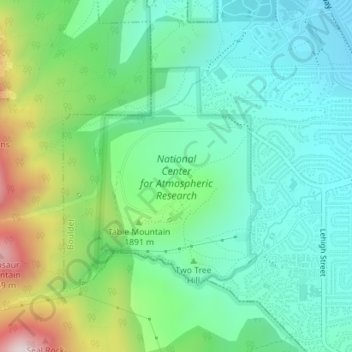
Nombre: Mapa topográfico National Center for Atmospheric Research, altitud, relieve.
Altitud media: 1.816 m
Altitud mínima: 1.644 m
Altitud máxima: 2.254 m
Gracias por apoyar a este sitio ❤️
Haz una donación
Haz una donación
Otros mapas topográficos
Haga clic en un mapa para ver su topografía, su altitud y su relieve.
Boulder
United States > Colorado > Boulder County > Boulder
Boulder is located at the base of the foothills of the Rocky Mountains, at an elevation of 5,430 feet (1,655 m) above sea level. Boulder is 25 miles (40 km) northwest of the Colorado State Capitol in Denver. It is home of the main campus of the University of Colorado, the state's largest university.
Altitud media: 1.977 m