
Mapa topográfico Rock City
Mapa interactivo
Haga clic en el mapa para ver la altitud.
Acerca de este mapa
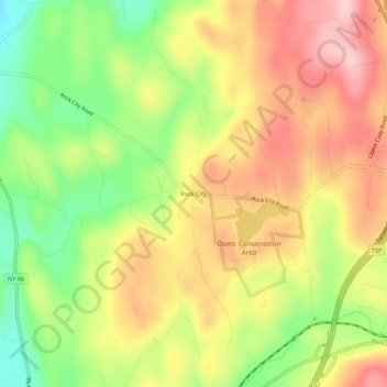
Nombre: Mapa topográfico Rock City, altitud, relieve.
Altitud media: 205 m
Altitud mínima: 94 m
Altitud máxima: 305 m
Otros mapas topográficos
Haga clic en un mapa para ver su topografía, su altitud y su relieve.
Malden Bridge
United States > New York > Columbia County > Town of Chatham
Malden Bridge, Town of Chatham, Columbia County, New York, 12115, United States
Altitud media: 151 m
Chatham Center
United States > New York > Columbia County > Town of Chatham
Chatham Center, Town of Chatham, Columbia County, New York, United States
Altitud media: 124 m
New Concord
United States > New York > Columbia County > Town of Chatham
New Concord, Town of Chatham, Columbia County, New York, 12060, United States
Altitud media: 254 m
Rayville
United States > New York > Columbia County > Town of Chatham
Rayville, Town of Chatham, Columbia County, New York, 12024, United States
Altitud media: 240 m
Riders
United States > New York > Columbia County > Town of Chatham
Riders, Town of Chatham, Columbia County, New York, 12024, United States
Altitud media: 216 m
Riders Mills
United States > New York > Columbia County > Town of Chatham
Riders Mills, Town of Chatham, Columbia County, New York, 12024, United States
Altitud media: 174 m
East Chatham
United States > New York > Columbia County > Town of Chatham
East Chatham, Town of Chatham, Columbia County, New York, 12060, United States
Altitud media: 242 m
Old Chatham
United States > New York > Columbia County > Town of Chatham
Old Chatham, Town of Chatham, Columbia County, New York, 12136, United States
Altitud media: 197 m
North Chatham
United States > New York > Columbia County > Town of Chatham
North Chatham, Town of Chatham, Columbia County, New York, 12132, United States
Altitud media: 120 m