
Mapa topográfico Pulau Ubin
Mapa interactivo
Haga clic en el mapa para ver la altitud.
Acerca de este mapa
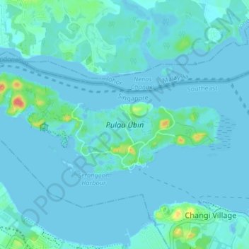
Nombre: Mapa topográfico Pulau Ubin, altitud, relieve.
Lugar: Pulau Ubin, Southeast, 508309, Singapore (1.39936 103.92622 1.42768 103.99238)
Altitud media: 6 m
Altitud mínima: -10 m
Altitud máxima: 60 m
Otros mapas topográficos
Haga clic en un mapa para ver su topografía, su altitud y su relieve.
East Coast Park (Zone H)
East Coast Park (Zone H), Tanah Merah, Southeast, Singapore
Altitud media: 5 m
Palau Tekong Camp
Singapore > Southeast > Rocky Hill
Palau Tekong Camp, Rocky Hill, Southeast, Singapore
Altitud media: 5 m