
Haz una donación
Mapa topográfico Yathkyed Lake
Haga clic en el mapa para ver la altitud.
Haz una donación
Yathkyed Lake
It is part of the Hearne Domain, Western Churchill province of the Churchill craton, which is the northwest section of the Canadian Shield. According to the Atlas of Canada the geographical centre of the country lies just south of the lake at 62°24′N 096°28′W / 62.400°N 96.467°W / 62.400; -96.467 (Geographical centre of Canada). Yathkyed lake lies at an elevation of 82 meters (269 feet). Some nearby locations or citites near Yathkyed lake are Windy Point at 9 kilometers south, Cairn Point at 17 kilometers east and Yellowknife at 520 kilometers north.
Haz una donación
Acerca de este mapa
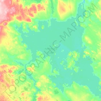
Nombre: Mapa topográfico Yathkyed Lake, altitud, relieve.
Lugar: Yathkyed Lake, Kivalliq Region, Nunavut, Canada (62.42380 -97.47136 62.47771 -97.39634)
Altitud media: 142 m
Altitud mínima: 139 m
Altitud máxima: 154 m
Haz una donación
Otros mapas topográficos
Haga clic en un mapa para ver su topografía, su altitud y su relieve.