
Haz una donación
Mapa topográfico Snowmass Village
Haga clic en el mapa para ver la altitud.
Haz una donación
Acerca de este mapa
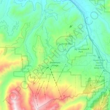
Nombre: Mapa topográfico Snowmass Village, altitud, relieve.
Altitud media: 2.675 m
Altitud mínima: 2.191 m
Altitud máxima: 3.922 m
Haz una donación
Otros mapas topográficos
Haga clic en un mapa para ver su topografía, su altitud y su relieve.
Castle Peak
United States > Colorado > Pitkin County
There are two other peaks in Colorado that have the same name: one in Eagle County at 39°46′23″N 106°50′04″W / 39.7730422°N 106.8344844°W / 39.7730422; -106.8344844, with an elevation 11,280+ feet, (3438+ m); and the other in Mesa County at 39°16′16″N 108°05′40″W /…
Altitud media: 3.909 m
Haz una donación
Capitol Peak
United States > Colorado > Pitkin County
At the trail head, at an altitude of 9,400 feet, following several switchbacks for half a mile will lead you to Daly Pass. Daly Pass is the first point of interest on Capitol Peak. This pass is recognized for its saddle-shaped ridge reaching 12,480 feet.
Altitud media: 3.750 m
Haz una donación
Maroon Bells
United States > Colorado > Pitkin County
Maroon Lake, elevation 2,920 m (9,580 ft), occupies a basin that was sculpted by Ice Age glaciers and later dammed by a landslide and rockfall debris from the steep slopes above the valley floor.
Altitud media: 3.691 m
Haz una donación