
Mapa topográfico Sebastopol
Mapa interactivo
Haga clic en el mapa para ver la altitud.
Sebastopol
Sebastopol's elevation is 65 to 250 feet (20 to 76 meters) above sea level. Its downtown is at the intersection of State Route 12 and State Route 116 (Gravenstein Highway), approximately 9 mi (14 km) west of U.S. Route 101.
Acerca de este mapa
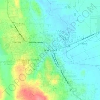
Nombre: Mapa topográfico Sebastopol, altitud, relieve.
Altitud media: 41 m
Altitud mínima: 14 m
Altitud máxima: 108 m