
Mapa topográfico Howe
Mapa interactivo
Haga clic en el mapa para ver la altitud.
Howe
Howe's elevation of 860 feet (260 m) is the highest point along US 75 between the Red River and the Gulf of Mexico.
Acerca de este mapa
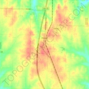
Nombre: Mapa topográfico Howe, altitud, relieve.
Lugar: Howe, Grayson County, Texas, 75459, United States (33.46537 -96.65025 33.53849 -96.59389)
Altitud media: 248 m
Altitud mínima: 218 m
Altitud máxima: 269 m
Otros mapas topográficos
Haga clic en un mapa para ver su topografía, su altitud y su relieve.
Howe
United States > Texas > Grayson County
Howe's elevation of 860 feet (260 m) is the highest point along US 75 between the Red River and the Gulf of Mexico.
Altitud media: 248 m