
Haz una donación
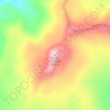
Mapa topográfico Sleepy Cat Peak
Haga clic en el mapa para ver la altitud.
Haz una donación
Sleepy Cat Peak
Sleepy Cat Peak, elevation 10,853 ft (3,308 m), is a summit in the Flat Tops of northwest Colorado. The mountain is east of Meeker in the White River National Forest of Rio Blanco County.
Haz una donación
Acerca de este mapa
Nombre: Mapa topográfico Sleepy Cat Peak, altitud, relieve.
Altitud media: 3.090 m
Altitud mínima: 2.861 m
Altitud máxima: 3.280 m
Haz una donación
Otros mapas topográficos
Haga clic en un mapa para ver su topografía, su altitud y su relieve.
Meeker
United States > Colorado > Rio Blanco County
According to the United States Census Bureau, the town has a total area of 2.9 square miles (7.5 km2), all of it land. The town is situated on the White River at an elevation of 6,250 feet above sea level.
Altitud media: 2.016 m
Meeker
United States > Colorado > Rio Blanco County
According to the United States Census Bureau, the town has a total area of 2.9 square miles (7.5 km2), all of it land. The town is situated on the White River at an elevation of 6,250 feet above sea level.
Altitud media: 2.016 m
Haz una donación