
Mapa topográfico Alhambra
Mapa interactivo
Haga clic en el mapa para ver la altitud.
Acerca de este mapa
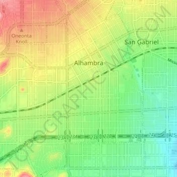
Nombre: Mapa topográfico Alhambra, altitud, relieve.
Lugar: Alhambra, Los Angeles County, California, United States (34.05994 -118.16484 34.11115 -118.10778)
Altitud media: 139 m
Altitud mínima: 89 m
Altitud máxima: 206 m
Otros mapas topográficos
Haga clic en un mapa para ver su topografía, su altitud y su relieve.
Mount San Antonio
United States > California > Los Angeles County
The prehistoric Hog Back landslide lies in the canyon of San Antonio Creek at 4000' elevation. When the slide occurred, it dammed the river, whose depth built up until the water was released catastrophically, forming a slot canyon which now holds some of the area's few good rock climbing routes (difficulty…
Altitud media: 2.675 m
Santa Monica Mountains
United States > California > Los Angeles County
On January 17, 2007, an unusually cold storm brought snow in the Santa Monica Mountains. The hills above Malibu picked up three inches (eight centimeters) of snow - the first measurable snow in fifty years. Snow was reported on Boney Peak in the winter of 2005; and in March 2006, snow also fell on the summit…
Altitud media: 201 m
Horsethief Canyon Park
United States > California > Los Angeles County > San Dimas
Altitud media: 373 m
Malibu Vista
United States > California > Los Angeles County > Unincorporated Santa Monica Mountains
Altitud media: 283 m
Santa Susana Mountains
United States > California > Los Angeles County > Unincorporated Chatsworth
Altitud media: 546 m
Lake Elizabeth
United States > California > Los Angeles County
The lake, at 3,228 ft (984 m) in elevation, is within the Angeles National Forest. It is a natural perennial lake, but may dry up entirely during drought years. It is south of the western Antelope Valley.
Altitud media: 1.065 m
Eaton Canyon Waterfall
United States > California > Los Angeles County > Pasadena
Altitud media: 639 m
Twin Lakes
United States > California > Los Angeles County > Unincorporated Chatsworth
Altitud media: 400 m
San Fernando Valley
United States > California > Los Angeles County > Los Angeles
Altitud media: 496 m
Veterans Administration
United States > California > Los Angeles County > Veterans Administration
Altitud media: 105 m
West Puente Valley
United States > California > Los Angeles County > West Puente Valley
Altitud media: 101 m
West Puente Valley
United States > California > Los Angeles County > West Puente Valley
Altitud media: 101 m
Monte Nido
United States > California > Los Angeles County > Unincorporated Santa Monica Mountains
Altitud media: 327 m
San Pedro Hill
United States > California > Los Angeles County > Rancho Palos Verdes
Altitud media: 285 m
Sierra Madre
United States > California > Los Angeles County > Sierra Madre > Sierra Madre
In 1908, the first Mt. Wilson Trail Race was run. This annual race was discontinued during WWII and reestablished in 1966. The 102nd anniversary of the first running of the Mount Wilson Trail Race and the 44th annual race was run in May 2010. Because of rain, mudslides, falling trees, soil erosion and…
Altitud media: 379 m
Agua Dulce
United States > California > Los Angeles County
Agua Dulce (pronunciation) (Spanish for "Sweet Water") is a census-designated place in Los Angeles County, California, United States. It lies at an elevation of 2,526 feet (770 m), northeast of Santa Clarita. The community had a population of 3,342 at the 2010 census and covers a geographic area of about 23…
Altitud media: 803 m
Rancho Santa Clarita
United States > California > Los Angeles County > Santa Clarita > Rancho Santa Clarita
Altitud media: 397 m
Rio de Los Angeles State Park State Recreational Area
United States > California > Los Angeles County > Los Angeles
Altitud media: 141 m