
Mapa topográfico Goudhurst
Mapa interactivo
Haga clic en el mapa para ver la altitud.
Acerca de este mapa
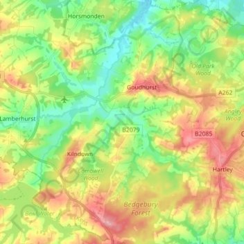
Nombre: Mapa topográfico Goudhurst, altitud, relieve.
Lugar: Goudhurst, Tunbridge Wells, Kent, England, United Kingdom (51.05639 0.40052 51.14477 0.51468)
Altitud media: 76 m
Altitud mínima: 24 m
Altitud máxima: 146 m
Otros mapas topográficos
Haga clic en un mapa para ver su topografía, su altitud y su relieve.
Royal Tunbridge Wells
United Kingdom > England > Kent > Tunbridge Wells
Royal Tunbridge Wells, Tunbridge Wells, Kent, England, TN1 2DL, United Kingdom
Altitud media: 99 m
Frittenden
United Kingdom > England > Kent > Tunbridge Wells
Frittenden, Tunbridge Wells, Kent, England, United Kingdom
Altitud media: 34 m
Rusthall Common Cricket Ground
United Kingdom > England > Kent > Tunbridge Wells > Rusthall
Rusthall Common Cricket Ground, Rusthall, Tunbridge Wells, Kent, England, United Kingdom
Altitud media: 99 m
Chalybeate Spring
United Kingdom > England > Kent > Tunbridge Wells > Kilndown
Chalybeate Spring, Spring Walk, Lamberhurst, Kilndown, Tunbridge Wells, Kent, England, TN3 8JB, United Kingdom
Altitud media: 65 m
Curtisden Green
United Kingdom > England > Kent > Tunbridge Wells
Curtisden Green, Goudhurst, Tunbridge Wells, Kent, England, TN17 1LL, United Kingdom
Altitud media: 50 m
Cranbrook
United Kingdom > England > Kent > Tunbridge Wells
Cranbrook, Tunbridge Wells, Kent, England, TN17 3ES, United Kingdom
Altitud media: 76 m
Rusthall
United Kingdom > England > Kent > Tunbridge Wells
Rusthall, Tunbridge Wells, Kent, England, United Kingdom
Altitud media: 100 m
Capel
United Kingdom > England > Kent > Tunbridge Wells
Capel, Tunbridge Wells, Kent, England, United Kingdom
Altitud media: 47 m
Paddock Wood
United Kingdom > England > Kent > Tunbridge Wells
Paddock Wood, Tunbridge Wells, Kent, England, United Kingdom
Altitud media: 33 m
Horsmonden
United Kingdom > England > Kent > Tunbridge Wells
Horsmonden, Tunbridge Wells, Kent, England, United Kingdom
Altitud media: 51 m
Speldhurst
United Kingdom > England > Kent > Tunbridge Wells
Speldhurst, Tunbridge Wells, Kent, England, United Kingdom
Altitud media: 89 m
Underground reservoir
United Kingdom > England > Kent > Tunbridge Wells > Hartley > Flishinghurst
Underground reservoir, Glassenbury Road, Flishinghurst, Cranbrook & Sissinghurst, Hartley, Tunbridge Wells, Kent, South East England, England, TN17 2QE, United Kingdom
Altitud media: 103 m
Hartley
United Kingdom > England > Kent > Tunbridge Wells > Hartley
Hartley, Tunbridge Wells, Kent, South East England, England, TN17 3PX, United Kingdom
Altitud media: 94 m
Hawkhurst
United Kingdom > England > Kent > Tunbridge Wells
Hawkhurst, Tunbridge Wells, Kent, England, United Kingdom
Altitud media: 67 m
Kilndown
United Kingdom > England > Kent > Tunbridge Wells > Kilndown
Kilndown, Tunbridge Wells, Kent, South East England, England, TN17 2RJ, United Kingdom
Altitud media: 71 m
Bidborough
United Kingdom > England > Kent > Tunbridge Wells
Bidborough, Tunbridge Wells, Kent, England, United Kingdom
Altitud media: 71 m
Benenden
United Kingdom > England > Kent > Tunbridge Wells > Benenden
Benenden, Tunbridge Wells, Kent, England, United Kingdom
Altitud media: 61 m
Matfield
United Kingdom > England > Kent > Tunbridge Wells
Matfield, Tunbridge Wells, Kent, England, TN12 7JT, United Kingdom
Altitud media: 82 m
Pembury
United Kingdom > England > Kent > Tunbridge Wells
Pembury, Tunbridge Wells, Kent, England, United Kingdom
Altitud media: 99 m
Langton Green
United Kingdom > England > Kent > Tunbridge Wells
Langton Green, Tunbridge Wells, Kent, England, TN3 0DT, United Kingdom
Altitud media: 94 m
Lamberhurst
United Kingdom > England > Kent > Tunbridge Wells
Lamberhurst, Tunbridge Wells, Kent, England, United Kingdom
Altitud media: 84 m
Sissinghurst
United Kingdom > England > Kent > Tunbridge Wells > Sissinghurst
Sissinghurst, Tunbridge Wells, Kent, South East England, England, TN17 2JF, United Kingdom
Altitud media: 66 m
The Common
United Kingdom > England > Kent > Tunbridge Wells > Sissinghurst
The Common, Cranbrook & Sissinghurst, Sissinghurst, Tunbridge Wells, Kent, England, TN17 2AE, United Kingdom
Altitud media: 64 m
Brenchley
United Kingdom > England > Kent > Tunbridge Wells
Brenchley, Tunbridge Wells, Kent, England, TN12 7NJ, United Kingdom
Altitud media: 68 m