
Haz una donación
Mapa topográfico Eckert
Haga clic en el mapa para ver la altitud.
Haz una donación
Acerca de este mapa
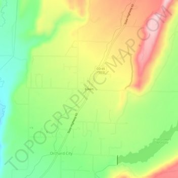
Nombre: Mapa topográfico Eckert, altitud, relieve.
Lugar: Eckert, Delta County, Colorado, 81418, United States (38.82276 -107.98284 38.86276 -107.94284)
Altitud media: 1.691 m
Altitud mínima: 1.585 m
Altitud máxima: 1.817 m
Haz una donación
Otros mapas topográficos
Haga clic en un mapa para ver su topografía, su altitud y su relieve.
Cedaredge
United States > Colorado > Delta County
Located in a protected valley at 6,100 feet (1,900 m) in elevation, the Cedaredge Golf Club course has natural cedars and winding creek beds.
Altitud media: 1.883 m
Haz una donación
Cedaredge
United States > Colorado > Delta County
Located in a protected valley at 6,100 feet (1,900 m) in elevation, the Cedaredge Golf Club course has natural cedars and winding creek beds.
Altitud media: 1.883 m
Cedaredge
United States > Colorado > Delta County
Located in a protected valley at 6,100 feet (1,900 m) in elevation, the Cedaredge Golf Club course has natural cedars and winding creek beds.
Altitud media: 1.883 m
Cedaredge
United States > Colorado > Delta County
Located in a protected valley at 6,100 feet (1,900 m) in elevation, the Cedaredge Golf Club course has natural cedars and winding creek beds.
Altitud media: 1.883 m
Haz una donación