
Haz una donación
Mapa topográfico Lederbach
Haga clic en el mapa para ver la altitud.
Haz una donación
Acerca de este mapa
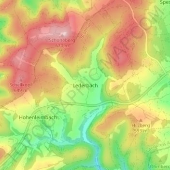
Nombre: Mapa topográfico Lederbach, altitud, relieve.
Altitud media: 550 m
Altitud mínima: 416 m
Altitud máxima: 676 m
Haz una donación
Otros mapas topográficos
Haga clic en un mapa para ver su topografía, su altitud y su relieve.
Laacher See
Deutschland > Rheinland-Pfalz > Landkreis Ahrweiler > Glees
Das geförderte vulkanische Material war vorwiegend von phonolithischem Typ, der nur in der dritten Phase einen zunehmend höheren Anteil an primitiverem mafischem Material enthielt. Über die Gesamtmenge des Materials herrscht Uneinigkeit. So ist von 6 km³ DRE entsprechend 16–20 km³ Lockermassen die Rede,…
Altitud media: 314 m
Bad Neuenahr-Ahrweiler
Deutschland > Rheinland-Pfalz > Landkreis Ahrweiler
Aus dem Jahr 1510 stammt die älteste überlieferte Stadtordnung für Ahrweiler. 36 Jahre später, 1546, kam es zur Rückeroberung der Grafschaft Neuenahr durch den Herzog von Jülich; seitdem war die Grafschaft mit dem Herzogtum Jülich als Amt Neuenahr vereint. Auch in Ahrweiler gab es Hexenverfolgungen.…
Altitud media: 257 m
Adenau
Deutschland > Rheinland-Pfalz > Landkreis Ahrweiler
Adenau liegt im Süden der Ahreifel – genauer am Rande des Naturraums Südliches Ahrbergland – im Tal des Adenauer Bachs, eines rechten Zuflusses der Ahr, der bei Adenau mit dem Exbach, dem Mittelbach, dem Näßbach und dem Krekelbach seinerseits einige Nebenbäche aufnimmt. Seitlich der Täler dieser…
Altitud media: 447 m
Haz una donación
Insul
Deutschland > Rheinland-Pfalz > Landkreis Ahrweiler
Insul liegt sieben Kilometer nördlich der Stadt Adenau auf beiden Seiten der Ahr. Die Wohnbebauung des Dorfs erstreckt sich auf einem relativ ebenen Gebiet und steigt im Südwesten am Rand der Anhöhe Burg 271 m ü. NHN minimal an. Das Gemeindegebiet wird naturräumlich größtenteils zum Dümpelfelder Ahrtal…
Altitud media: 315 m
Remagen
Deutschland > Rheinland-Pfalz > Landkreis Ahrweiler
Remagen liegt am nördlichen Mittelrhein gegenüber der rechtsrheinischen Ortsgemeinde Erpel am Nordrand der Goldenen Meile, einer bis nach Bad Breisig reichenden fruchtbaren Talebene, die südlich des Ortsteils Kripp die Ahrmündung aufnimmt. Nach Nordwesten hin verengt sich das Stadtzentrum mit dem Rheintal;…
Altitud media: 168 m
Haz una donación
Burgbrohl
Deutschland > Rheinland-Pfalz > Landkreis Ahrweiler
Die Kaiserhalle ist eine als Ball- und Theatersaal konzipierte Festhalle. Die Einweihung fand am 4. September 1896, anlässlich der Feierlichkeiten zum Sedantag statt. Der Innenraum hat eine runde Tanzfläche und bietet über 500 Gästen Platz. Die Halle erhebt sich auf einem Bruchsteinfundament in…
Altitud media: 230 m
Mayschoß
Deutschland > Rheinland-Pfalz > Landkreis Ahrweiler
Unmittelbar nach der Hochwasserkatastrophe im Sommer 2021 wurde eine asphaltierte Straße Richtung Kalenborner Höhe gebaut, da Mayschoß über die Bundesstraße 267 nicht erreichbar war.
Altitud media: 264 m
Haz una donación
Schuld
Deutschland > Rheinland-Pfalz > Landkreis Ahrweiler
Die Gemeinde ist durch die Landesstraßen 73 und 75 entlang der Ahr erschlossen. Über die Landesstraßen 165 ist Schuld Richtung Bad Münstereifel, über die K 16 und K 26 an weitere benachbarte Höhenorte angebunden.
Altitud media: 344 m
Wassenach
Deutschland > Rheinland-Pfalz > Landkreis Ahrweiler
Wassenach liegt in der Osteifel nördlich des Laacher Sees auf einem von Süden nach Norden stetig abfallenden Bergrücken. Die Ortschaft umfasst dabei Höhenlagen zwischen 245 m ü. NHN und 320 m ü. NHN. Westlich erhebt sich der Veitskopf, wo das Gemeindegebiet mit 428 m ü. NHN seinen höchsten Bodenpunkt…
Altitud media: 289 m
Haz una donación
Wehr
Deutschland > Rheinland-Pfalz > Landkreis Ahrweiler
Im Wehrer Talkessel wurden Überreste einer römischen Besiedlung gefunden, die aufgrund landwirtschaftlicher Nutzung aber nicht mehr rekonstruierbar sind. Die erste urkundliche Erwähnung stammt aus dem Jahr 920. Das Dorf Wehr gehörte seit der Gründung des Klosters Steinfeld um das Jahr 1069 bis 1073 zu…
Altitud media: 386 m
Rech
Deutschland > Rheinland-Pfalz > Landkreis Ahrweiler
Rech liegt am Südufer der Ahr am Fuße des Steinerbergs, einer der höheren Berge des Ahrgebirges, etwa 30 Kilometer südlich von Bonn und 50 Kilometer nordwestlich von Koblenz.
Altitud media: 307 m
Haz una donación
Grafschaft
Deutschland > Rheinland-Pfalz > Landkreis Ahrweiler
Die Gemeinde Grafschaft liegt nördlich der Kreisstadt Bad Neuenahr-Ahrweiler, etwa 15 Kilometer südwestlich der Bundesstadt Bonn. Das 57,55 Quadratkilometer große Gemeindegebiet liegt am Rande der Voreifel im Osten der Eifel, am Übergang zum Mittelrheintal. Der westliche Teil des Gebietes steigt ins…
Altitud media: 214 m
Dernau
Deutschland > Rheinland-Pfalz > Landkreis Ahrweiler
Ab Oktober 1943 wurde im Rahmen der Untertageverlagerungen von kriegswichtigen Industrien fünf Eisenbahntunnel der nicht fertig gestellten Bahnstrecke Neuss – Ahrtal zwischen Ahrweiler und Rech umgebaut, um mit Häftlingen vom KZ-Außenlager Rebstock Komponenten für die V2 Produktion herzustellen. Wurde…
Altitud media: 259 m
Kirchdaun
Deutschland > Rheinland-Pfalz > Landkreis Ahrweiler > Bad Neuenahr-Ahrweiler
Es wird angenommen, dass der Name Kirchdaun keltischen oder gallorömischen Ursprungs ist. Er enthält den Wortstamm -dunum, der so viel bedeutet wie Höhenbefestigung, und bezog sich wohl auf umliegende, markante Anhöhen. Aus römischer Zeit sind im Gebiet von Kirchdaun zwei Siedlungsstellen bekannt,…
Altitud media: 181 m
Haz una donación
Haz una donación
Ahrweiler
Deutschland > Rheinland-Pfalz > Landkreis Ahrweiler > Bad Neuenahr-Ahrweiler > Walporzheim
Der Weiße Turm aus dem 13. Jahrhundert ist ein Gebäude mit reicher Geschichte. Die Barockhaube ist von 1668 (vorher gotischer Spitzturm). Nach den Rittern von Staffel, die hier ihren Adelssitz hatten, wird er auch „Staffeler Turm“ genannt, aber auch „Weißer Turm“ nach den „Weißen“ Chorherren…
Altitud media: 283 m
Neuenahr
Deutschland > Rheinland-Pfalz > Landkreis Ahrweiler > Bad Neuenahr-Ahrweiler
Altitud media: 242 m
Waldorf
Deutschland > Rheinland-Pfalz > Landkreis Ahrweiler
Waldorf liegt im Vinxtbachtal und am Rande des Vulkanparks Brohltal zwischen Sinzig und Niederzissen, unterhalb des erloschenen Vulkans Bausenberg. Zu Waldorf gehören die Wohnplätze Adamsmühle, Berghotel Iwelstein, Marienhöhe und Ockenfelsmühle.
Altitud media: 229 m
Haz una donación
Marienthal
Deutschland > Rheinland-Pfalz > Landkreis Ahrweiler > Bad Neuenahr-Ahrweiler > Marienthal
Der Weinort Marienthal besitzt fünf Einzellagen. Es handelt sich durchweg um Steillagen mit Grauwackeverwitterungen im oberen Bereich und Löß und Lehm im unteren Abschnitt. Die erzeugten Weine fallen von den Trauben im oberen Bereich (um 200–250 m Höhe) fruchtig und von den Rebstöcken im unteren…
Altitud media: 232 m
Kripp
Deutschland > Rheinland-Pfalz > Landkreis Ahrweiler > Remagen
Kripp teilt sich in das Ober- und Unterdorf, unterschieden nach der Höhenlage am Rheinufer. Sein Wahrzeichen ist der Kripper Wasserturm (erbaut 1904), der sich weithin sichtbar über die Gärten erhebt und unter Denkmalschutz gestellt wurde.
Altitud media: 75 m
Burg Kreuzberg
Deutschland > Rheinland-Pfalz > Landkreis Ahrweiler > Kreuzberg
Die Burg Kreuzberg steht auf einem kleinen Felskegel oberhalb des Altenahrer Ortsteils Kreuzberg. Die Anlage befindet sich auf einem dreieckigen Felsplateau, das an einer Seite steil zur Ahr abfällt, und gehört damit zum Typus der Höhenburg.
Altitud media: 271 m
Burg Aremberg
Deutschland > Rheinland-Pfalz > Landkreis Ahrweiler > Aremberg
Die Burg Aremberg bei Aremberg im rheinland-pfälzischen Landkreis Ahrweiler ist die Ruine einer mittelalterlichen Höhenburg auf dem Aremberg im Ahrgebirge (Eifel).
Altitud media: 438 m
Haz una donación
Herschbroich
Deutschland > Rheinland-Pfalz > Landkreis Ahrweiler
Seit Beginn der Aufzeichnungen Anfang des 19. Jahrhunderts schwankte die Bevölkerungszahl wenig und liegt heute nur unwesentlich höher als vor etwa 200 Jahren.
Altitud media: 479 m
Haz una donación
Wiesemscheid
Deutschland > Rheinland-Pfalz > Landkreis Ahrweiler
Wiesemscheid liegt sechs Kilometer südwestlich der Stadt Adenau auf einem Gelände, das für die Hocheifel vergleichsweise wenig Höhenunterschiede zeigt. Nach Norden fällt das Gemeindegebiet ins Tal des Wirftbachs, nach Süden in das des Trierbachs ab, wo es mit etwa 405 m ü. NHN seinen niedrigsten…
Altitud media: 484 m
53474
Deutschland > Rheinland-Pfalz > Landkreis Ahrweiler > Bad Neuenahr-Ahrweiler
Altitud media: 220 m
Haz una donación
Haz una donación
Wimbach
Deutschland > Rheinland-Pfalz > Landkreis Ahrweiler
Wimbach liegt in der Hocheifel, zweieinhalb Kilometer südwestlich der Stadt Adenau sowie einen Kilometer westlich des Nürburgrings. Der Ort weist die Siedlungsform eines Straßendorfs auf, das sich auf einem in nordöstlicher Richtung stark abfallenden Gelände erstreckt. Die Wohnbebauung umfasst Höhenlagen…
Altitud media: 456 m
Rodderberg
Deutschland > Rheinland-Pfalz > Landkreis Ahrweiler > Remagen > Rolandswerth
Der Rodderberg liegt direkt oberhalb vom nördlichen Ausgang des Mittelrheintals. Zusammen mit dem fast direkt gegenüberliegenden Drachenfels verengt er das Rheintal. Diese Engstelle bildet die Südgrenze der Kölner Bucht, während sich südlich dieser Engstelle die kleine Talverbreiterung von Oberwinter…
Altitud media: 106 m
Haz una donación
Quiddelbach
Deutschland > Rheinland-Pfalz > Landkreis Ahrweiler
Quiddelbach liegt in einem Tal vier Kilometer südlich der Stadt Adenau auf einem nach Nordosten gemeinsam mit dem Breidscheider Bach abfallenden Gelände. Die Wohnbebauung des Dorfs umfasst Höhenlagen zwischen 440 m ü. NHN und 500 m ü. NHN. Südlich von Quiddelbach erhebt sich der Selberg (584 m ü. NHN),…
Altitud media: 536 m
Haz una donación
Heppingen
Deutschland > Rheinland-Pfalz > Landkreis Ahrweiler > Bad Neuenahr-Ahrweiler
Altitud media: 131 m
Haz una donación
Bad Bodendorf
Deutschland > Rheinland-Pfalz > Landkreis Ahrweiler > Sinzig
Bad Bodendorf liegt am unteren Verlauf der Ahr im Tal. Im Norden und Süden ist es von den Anhöhen umgeben, nordwestlich liegt der Reisberg und südwestlich der Mühlenberg, welche eine letzte engere Stelle vor dem Rheintal bilden.
Altitud media: 128 m
Heimersheim
Deutschland > Rheinland-Pfalz > Landkreis Ahrweiler > Bad Neuenahr-Ahrweiler
Altitud media: 206 m
Haz una donación
Dungkopfsee
Deutschland > Rheinland-Pfalz > Landkreis Ahrweiler > Remagen > Unkelbach
Altitud media: 177 m
Lohrsdorf
Deutschland > Rheinland-Pfalz > Landkreis Ahrweiler > Bad Neuenahr-Ahrweiler
Altitud media: 141 m
Galenberg
Deutschland > Rheinland-Pfalz > Landkreis Ahrweiler
Galenberg liegt auf einer Anhöhe (etwa 300–480 m ü. NHN), rund drei Kilometer südwestlich von Niederzissen. Im Westen liegt der Engeler Kopf, der Brenker Schellkopf und dahinter der Bockshahn bei Spessart. Im Nordwesten überragt der Perlkopf die hügelige Landschaft. Rechts davor liegen Hain und die…
Altitud media: 354 m
Ramersbach
Deutschland > Rheinland-Pfalz > Landkreis Ahrweiler > Bad Neuenahr-Ahrweiler
Ramersbach liegt ca. 8 km südlich der Kernstadtteile von Bad Neuenahr-Ahrweiler am Kreuzungspunkt der Landesstraßen 84 und 85 und bildet den geographisch höchstgelegenen (der topographisch höchste Punkt heißt „Häuschen“ auf einer Höhe von 506,5 m ü. NHN), geschichtlich jedoch jüngsten Stadtteil…
Altitud media: 414 m
Haz una donación
Adenau
Deutschland > Rheinland-Pfalz > Landkreis Ahrweiler
Adenau liegt im Süden der Ahreifel – genauer am Rande des Naturraums Südliches Ahrbergland – im Tal des Adenauer Bachs, eines rechten Zuflusses der Ahr, der bei Adenau mit dem Exbach, dem Mittelbach, dem Näßbach und dem Krekelbach seinerseits einige Nebenbäche aufnimmt. Seitlich der Täler dieser…
Altitud media: 447 m
53474
Deutschland > Rheinland-Pfalz > Landkreis Ahrweiler > Bad Neuenahr-Ahrweiler
Altitud media: 220 m
Haz una donación
Neuenahr
Deutschland > Rheinland-Pfalz > Landkreis Ahrweiler > Bad Neuenahr-Ahrweiler
Altitud media: 242 m
Herschbroich
Deutschland > Rheinland-Pfalz > Landkreis Ahrweiler
Seit Beginn der Aufzeichnungen Anfang des 19. Jahrhunderts schwankte die Bevölkerungszahl wenig und liegt heute nur unwesentlich höher als vor etwa 200 Jahren.
Altitud media: 479 m
Haz una donación