
Mapa topográfico Böhl-Iggelheim
Mapa interactivo
Haga clic en el mapa para ver la altitud.
Acerca de este mapa
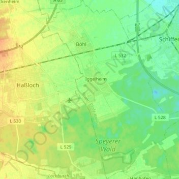
Nombre: Mapa topográfico Böhl-Iggelheim, altitud, relieve.
Altitud media: 109 m
Altitud mínima: 96 m
Altitud máxima: 123 m
Böhl entstand im 7./8. Jahrhundert als fränkische Gründung und wurde 780 das erste Mal in einer Schenkungsurkunde im Lorscher Codex unter dem Namen Buhilo erwähnt. Der Name, der so viel wie „Anhöhe“ bedeutet, ist seit 1602 in der heutigen Form belegt.
Otros mapas topográficos
Haga clic en un mapa para ver su topografía, su altitud y su relieve.
Römerberg-Dudenhofen
Deutschland > Rheinland-Pfalz > Rhein-Pfalz-Kreis
Römerberg-Dudenhofen, Rhein-Pfalz-Kreis, Rheinland-Pfalz, Deutschland
Altitud media: 107 m
Fußgönheim
Deutschland > Rheinland-Pfalz > Rhein-Pfalz-Kreis
Fußgönheim, Maxdorf, Rhein-Pfalz-Kreis, Rheinland-Pfalz, 67136, Deutschland
Altitud media: 98 m
Harthausen
Deutschland > Rheinland-Pfalz > Rhein-Pfalz-Kreis
Harthausen, Römerberg-Dudenhofen, Rhein-Pfalz-Kreis, Rheinland-Pfalz, 67376, Deutschland
Altitud media: 110 m
Schauernheim
Deutschland > Rheinland-Pfalz > Rhein-Pfalz-Kreis > Dannstadt-Schauernheim
Schauernheim, Dannstadt-Schauernheim, Rhein-Pfalz-Kreis, Rheinland-Pfalz, 67125, Deutschland
Altitud media: 100 m
Kleinniedesheim
Deutschland > Rheinland-Pfalz > Rhein-Pfalz-Kreis
Kleinniedesheim, Lambsheim-Heßheim, Rhein-Pfalz-Kreis, Rheinland-Pfalz, Deutschland
Altitud media: 103 m
Mutterstadt
Deutschland > Rheinland-Pfalz > Rhein-Pfalz-Kreis
Mutterstadt, Rhein-Pfalz-Kreis, Rheinland-Pfalz, 67112, Deutschland
Altitud media: 97 m
Altrip
Deutschland > Rheinland-Pfalz > Rhein-Pfalz-Kreis
Altrip, Rheinauen, Rhein-Pfalz-Kreis, Rheinland-Pfalz, 67122, Deutschland
Altitud media: 96 m
Schifferstadt
Deutschland > Rheinland-Pfalz > Rhein-Pfalz-Kreis
Schifferstadt, Rhein-Pfalz-Kreis, Rheinland-Pfalz, 67105, Deutschland
Altitud media: 101 m
Limburgerhof
Deutschland > Rheinland-Pfalz > Rhein-Pfalz-Kreis
Limburgerhof, Rhein-Pfalz-Kreis, Rheinland-Pfalz, 67117, Deutschland
Altitud media: 97 m
Lambsheim
Deutschland > Rheinland-Pfalz > Rhein-Pfalz-Kreis
Lambsheim, Lambsheim-Heßheim, Rhein-Pfalz-Kreis, Rheinland-Pfalz, 67245, Deutschland
Altitud media: 101 m
Bobenheim-Roxheim
Deutschland > Rheinland-Pfalz > Rhein-Pfalz-Kreis
Bobenheim-Roxheim, Rhein-Pfalz-Kreis, Rheinland-Pfalz, 67240, Deutschland
Altitud media: 94 m
Hochdorf-Assenheim
Deutschland > Rheinland-Pfalz > Rhein-Pfalz-Kreis
Hochdorf-Assenheim, Dannstadt-Schauernheim, Rhein-Pfalz-Kreis, Rheinland-Pfalz, 67126, Deutschland
Altitud media: 107 m
Otterstadt
Deutschland > Rheinland-Pfalz > Rhein-Pfalz-Kreis
Otterstadt, Rheinauen, Rhein-Pfalz-Kreis, Rheinland-Pfalz, 67166, Deutschland
Altitud media: 97 m
Waldsee
Deutschland > Rheinland-Pfalz > Rhein-Pfalz-Kreis
Waldsee, Rheinauen, Rhein-Pfalz-Kreis, Rheinland-Pfalz, 67165, Deutschland
Altitud media: 96 m
Heuchelheim bei Frankenthal
Deutschland > Rheinland-Pfalz > Rhein-Pfalz-Kreis > Heuchelheim bei Frankenthal
Heuchelheim bei Frankenthal, Lambsheim-Heßheim, Rhein-Pfalz-Kreis, Rheinland-Pfalz, Deutschland
Altitud media: 106 m
Dudenhofen
Deutschland > Rheinland-Pfalz > Rhein-Pfalz-Kreis
Dudenhofen, Römerberg-Dudenhofen, Rhein-Pfalz-Kreis, Rheinland-Pfalz, 67373, Deutschland
Altitud media: 105 m
Maxdorf
Deutschland > Rheinland-Pfalz > Rhein-Pfalz-Kreis
Maxdorf, Rhein-Pfalz-Kreis, Rheinland-Pfalz, 67133, Deutschland
Altitud media: 97 m
Rehhütte
Deutschland > Rheinland-Pfalz > Rhein-Pfalz-Kreis > Limburgerhof > Rehhütte
Rehhütte, Limburgerhof, Rhein-Pfalz-Kreis, Rheinland-Pfalz, 67117, Deutschland
Altitud media: 98 m
Rödersheim-Gronau
Deutschland > Rheinland-Pfalz > Rhein-Pfalz-Kreis
Rödersheim-Gronau, Dannstadt-Schauernheim, Rhein-Pfalz-Kreis, Rheinland-Pfalz, 67127, Deutschland
Altitud media: 107 m
Beindersheim
Deutschland > Rheinland-Pfalz > Rhein-Pfalz-Kreis
Beindersheim, Lambsheim-Heßheim, Rhein-Pfalz-Kreis, Rheinland-Pfalz, Deutschland
Altitud media: 97 m
Heßheim
Deutschland > Rheinland-Pfalz > Rhein-Pfalz-Kreis > Heßheim
Heßheim, Lambsheim-Heßheim, Rhein-Pfalz-Kreis, Rheinland-Pfalz, 67258, Deutschland
Altitud media: 98 m
Römerberg
Deutschland > Rheinland-Pfalz > Rhein-Pfalz-Kreis
Römerberg, Römerberg-Dudenhofen, Rhein-Pfalz-Kreis, Rheinland-Pfalz, 67354, Deutschland
Altitud media: 104 m
Neuhofen
Deutschland > Rheinland-Pfalz > Rhein-Pfalz-Kreis
Neuhofen, Rheinauen, Rhein-Pfalz-Kreis, Rheinland-Pfalz, 67141, Deutschland
Altitud media: 96 m
Dannstadt
Deutschland > Rheinland-Pfalz > Rhein-Pfalz-Kreis > Dannstadt-Schauernheim
Dannstadt, Dannstadt-Schauernheim, Rhein-Pfalz-Kreis, Rheinland-Pfalz, 67125, Deutschland
Altitud media: 101 m
Bobenheim
Deutschland > Rheinland-Pfalz > Rhein-Pfalz-Kreis > Bobenheim-Roxheim
Bobenheim, Bobenheim-Roxheim, Rhein-Pfalz-Kreis, Rheinland-Pfalz, Deutschland
Altitud media: 92 m