
Mapa topográfico Schunnemunk State Park
Mapa interactivo
Haga clic en el mapa para ver la altitud.
Acerca de este mapa
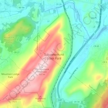
Nombre: Mapa topográfico Schunnemunk State Park, altitud, relieve.
Altitud media: 213 m
Altitud mínima: 66 m
Altitud máxima: 506 m
Otros mapas topográficos
Haga clic en un mapa para ver su topografía, su altitud y su relieve.
Highland Mills
United States > New York > Orange County > Village of Woodbury
Highland Mills, Village of Woodbury, Town of Woodbury, Orange County, New York, 10930, United States
Altitud media: 208 m
Central Valley
United States > New York > Orange County > Village of Woodbury
Central Valley, Village of Woodbury, Town of Woodbury, Orange County, New York, 10917, United States
Altitud media: 205 m