
Mapa topográfico La Ville
Mapa interactivo
Haga clic en el mapa para ver la altitud.
Acerca de este mapa
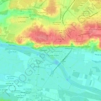
Nombre: Mapa topográfico La Ville, altitud, relieve.
Altitud media: 53 m
Altitud mínima: 24 m
Altitud máxima: 103 m
Otros mapas topográficos
Haga clic en un mapa para ver su topografía, su altitud y su relieve.
La Ville
France > Centre-Val de Loire > Indre-et-Loire > Chinon > La Ville
La Ville, Chinon, Indre-et-Loire, Centre-Val de Loire, France métropolitaine, 37500, France
Altitud media: 52 m
Le Jardin Anglais
France > Centre-Val de Loire > Indre-et-Loire > Chinon
Le Jardin Anglais, Chinon, Indre-et-Loire, Centre-Val de Loire, France métropolitaine, 37500, France
Altitud media: 52 m
Saint-Jean
France > Centre-Val de Loire > Indre-et-Loire > Chinon
Saint-Jean, Chinon, Indre-et-Loire, Centre-Val de Loire, France métropolitaine, 37500, France
Altitud media: 59 m
Mon Plaisir
France > Centre-Val de Loire > Indre-et-Loire > Chinon
Mon Plaisir, Chinon, Indre-et-Loire, Centre-Val de Loire, France métropolitaine, 37500, France
Altitud media: 50 m
L'Île de Tours
France > Centre-Val de Loire > Indre-et-Loire > Chinon
L'Île de Tours, Chinon, Indre-et-Loire, Centre-Val de Loire, France métropolitaine, 37500, France
Altitud media: 51 m
Les Courances
France > Centre-Val de Loire > Indre-et-Loire > Chinon
Les Courances, Chinon, Indre-et-Loire, Centre-Val de Loire, France métropolitaine, 37500, France
Altitud media: 54 m
La Croix de Saint-Jean
France > Centre-Val de Loire > Indre-et-Loire > Chinon
La Croix de Saint-Jean, Chinon, Indre-et-Loire, Centre-Val de Loire, France métropolitaine, 37500, France
Altitud media: 62 m
Les Hucherolles
France > Centre-Val de Loire > Indre-et-Loire > Chinon > Les Hucherolles
Les Hucherolles, Chinon, Indre-et-Loire, Centre-Val de Loire, France métropolitaine, 37500, France
Altitud media: 57 m
Les Ganaudières
France > Centre-Val de Loire > Indre-et-Loire > Chinon > Les Ganaudières
Les Ganaudières, Chinon, Indre-et-Loire, Centre-Val de Loire, France métropolitaine, 37500, France
Altitud media: 61 m
Le Vieux Marché
France > Centre-Val de Loire > Indre-et-Loire > Chinon
Le Vieux Marché, Chinon, Indre-et-Loire, Centre-Val de Loire, France métropolitaine, 37500, France
Altitud media: 51 m
Le Bois de la Grille
France > Centre-Val de Loire > Indre-et-Loire > Chinon > Le Villier
Le Bois de la Grille, Le Villier, Chinon, Indre-et-Loire, Centre-Val de Loire, France métropolitaine, 37500, France
Altitud media: 75 m
La Rochelle
France > Centre-Val de Loire > Indre-et-Loire > Chinon
La Rochelle, Chinon, Indre-et-Loire, Centre-Val de Loire, France métropolitaine, 37500, France
Altitud media: 58 m
Coteau de Saint-Martin
France > Centre-Val de Loire > Indre-et-Loire > Chinon
Coteau de Saint-Martin, Chinon, Indre-et-Loire, Centre-Val de Loire, France métropolitaine, 37500, France
Altitud media: 55 m
La Croix
France > Centre-Val de Loire > Indre-et-Loire > Chinon > La Croix
La Croix, Chinon, Indre-et-Loire, Centre-Val de Loire, France métropolitaine, 37500, France
Altitud media: 51 m
Les Grésillons
France > Centre-Val de Loire > Indre-et-Loire > Chinon
Les Grésillons, Chinon, Indre-et-Loire, Centre-Val de Loire, France métropolitaine, 37500, France
Altitud media: 64 m
Faubourg Saint-Jacques
France > Centre-Val de Loire > Indre-et-Loire > Chinon
Faubourg Saint-Jacques, Chinon, Indre-et-Loire, Centre-Val de Loire, France métropolitaine, 37500, France
Altitud media: 50 m