
Haz una donación
Mapa topográfico Chiusa di Pesio
Haga clic en el mapa para ver la altitud.
Haz una donación
Chiusa di Pesio
Chiusa di Pesio is located at the beginning of the Pesio Valley (its altitude ranges from 575 metres of the main town up to over 2,600 metres of the highest peaks). The main hamlets are San Bartolomeo and Vigna, located in the highest part of the valley, and Combe, Santa Maria Rocca and Abrau which are located more in the plain. Pesio River crosses the whole valley and its spring is called "Pis" (at 1,500 meters above sea level). The town is located between two hills, Mount Cavanero and Mombrisone. On the first one there are the ruins of the Mirabello Castle that dominates the town, and on the second one there is a nineteenth century hunting building. Chiusa di Pesio is 15 km from Cuneo and the nearest motorway is in Mondovì (called A6 Torino-Savona), located about 20 km south of Chiusa di Pesio.
Haz una donación
Acerca de este mapa
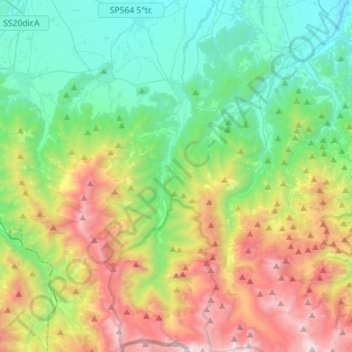
Nombre: Mapa topográfico Chiusa di Pesio, altitud, relieve.
Lugar: Chiusa di Pesio, Cuneo, Piedmont, 12013, Italy (44.17266 7.60340 44.37582 7.71687)
Altitud media: 1.147 m
Altitud mínima: 427 m
Altitud máxima: 2.642 m
Haz una donación
Otros mapas topográficos
Haga clic en un mapa para ver su topografía, su altitud y su relieve.
Monviso
Italy > Piedmont > Cuneo > Pontechianale
Monte Viso is the location of a neolithic jadeite quarry, at an elevation of 2000 to 2400 metres. Its productivity peaked around 5000 BC. The jadeite was used to make cult axes, which are found all over western Europe. One such ceremonial axe head was found as far away as a small hill called Tristia in Western…
Altitud media: 2.985 m
Croce di Envie - Cima Bracco
Italy > Piedmont > Cuneo > Sanfront
The Monte Bracco (though the name is sometimes shortened to Mombracco) is a mountain in the Cottian Alps with an elevation of 1,307 meters above sea level. It is located between the Valle Po, the Valle Infernotto [it], and the Cuneo plain.
Altitud media: 947 m
Monviso
Italy > Piedmont > Cuneo > Pontechianale
Monte Viso is the location of a Neolithic jadeite quarry, at an elevation of 2,000 to 2,400 metres. Its productivity peaked around 5000 BC. The jadeite was used to make cult axes, which are found all over western Europe. One such ceremonial axe head was found as far away as a small hill called Tristia in…
Altitud media: 2.985 m
Haz una donación
Haz una donación
Haz una donación
Haz una donación
Haz una donación
Monviso
Italy > Piedmont > Cuneo > Pontechianale
Monte Viso is the location of a neolithic jadeite quarry, at an elevation of 2,000 to 2,400 metres. Its productivity peaked around 5000 BC. The jadeite was used to make cult axes, which are found all over western Europe. One such ceremonial axe head was found as far away as a small hill called Tristia in…
Altitud media: 2.985 m
Haz una donación
Haz una donación
Haz una donación
Haz una donación
Haz una donación
Giardino Famiglia Allemandi
Italy > Piedmont > Cuneo > Villar San Costanzo > Pramallé
Altitud media: 654 m
Haz una donación