
Haz una donación
Mapa topográfico Valenzuela
Haga clic en el mapa para ver la altitud.
Haz una donación
Valenzuela
Valenzuela is a municipality in the province of Córdoba, Spain. In 2016 it had 1208 inhabitants. Its surface area is 19 km² and has a density of 63.58 inhabitants / km². It is located at an altitude of 341 meters above sea level and 84 kilometers from the capital of the province, Córdoba.
Haz una donación
Acerca de este mapa
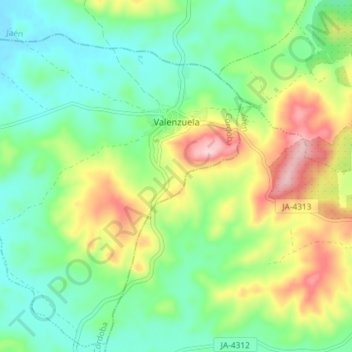
Nombre: Mapa topográfico Valenzuela, altitud, relieve.
Lugar: Valenzuela, Córdoba, Andalusia, Spain (37.73850 -4.27931 37.79406 -4.20658)
Altitud media: 334 m
Altitud mínima: 258 m
Altitud máxima: 480 m
Haz una donación
Otros mapas topográficos
Haga clic en un mapa para ver su topografía, su altitud y su relieve.
Mijas
Spain > Andalusia > Costa del Sol Occidental > Mijas > Mijas
The climate changes gradually with increasing elevation in the mountains. Temperatures can drop to 10 °C (50 °F). In the peaks, over 600 m (2,000 ft) high, some ice may form in winter, while precipitation increases to almost 800 mm (32 in).
Altitud media: 447 m
Haz una donación