
Mapa topográfico Deer Park
Mapa interactivo
Haga clic en el mapa para ver la altitud.
Acerca de este mapa
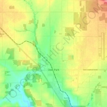
Nombre: Mapa topográfico Deer Park, altitud, relieve.
Altitud media: 658 m
Altitud mínima: 623 m
Altitud máxima: 695 m
Deer Park is located at 47°57′25″N 117°28′13″W / 47.95694°N 117.47028°W / 47.95694; -117.47028 (47.956922, -117.470230), at an elevation of 2,123 feet (647 m) above sea level.
Otros mapas topográficos
Haga clic en un mapa para ver su topografía, su altitud y su relieve.
Spokane
United States > Washington > Spokane County
Spokane, Spokane County, Washington, United States
Altitud media: 655 m
Mystic Falls
United States > Washington > Spokane County
Mystic Falls, Spokane County, Washington, 99224, United States
Altitud media: 660 m
Newman Lake
United States > Washington > Spokane County
Newman Lake, Spokane County, Washington, 99025, United States
Altitud media: 661 m
Hog Lake
United States > Washington > Spokane County
Hog Lake, Spokane County, Washington, United States
Altitud media: 664 m
Mead
United States > Washington > Spokane County
Mead, Spokane County, Washington, 99021, United States
Altitud media: 585 m
Silver Lake
United States > Washington > Spokane County
Silver Lake, Spokane County, Washington, 99022, United States
Altitud media: 741 m
Country Homes
United States > Washington > Spokane County
Country Homes, Spokane County, Washington, 99251, United States
Altitud media: 599 m
Cheney
United States > Washington > Spokane County
Cheney, Spokane County, Washington, United States
Altitud media: 728 m
Airway Heights
United States > Washington > Spokane County
Airway Heights, Spokane County, Washington, 99001, United States
Altitud media: 724 m
Millwood
United States > Washington > Spokane County
Millwood, Spokane County, Washington, United States
Altitud media: 600 m
Mount Spokane
United States > Washington > Spokane County
Mount Spokane, Spokane County, Washington, United States
Altitud media: 1.475 m
Spokane Valley
United States > Washington > Spokane County
Spokane Valley, Spokane County, Washington, United States
Altitud media: 673 m
Liberty Lake
United States > Washington > Spokane County
Liberty Lake, Spokane County, Washington, 99019, United States
Altitud media: 644 m
Nine Mile Falls
United States > Washington > Spokane County
Nine Mile Falls, Spokane County, Washington, 99026, United States
Altitud media: 536 m
Riverside State Park
United States > Washington > Spokane County > Spokane
Riverside State Park, Spokane, Spokane County, Washington, United States
Altitud media: 645 m
Medical Lake
United States > Washington > Spokane County
Medical Lake, Spokane County, Washington, 99022, United States
Altitud media: 738 m
Medical Lake
United States > Washington > Spokane County > Medical Lake > Medical Lake
Medical Lake, Spokane County, Washington, 99022, United States
Altitud media: 747 m
Chattaroy
United States > Washington > Spokane County > Chattaroy
Chattaroy, Spokane County, Washington, 99005, United States
Altitud media: 559 m