
Haz una donación
Mapa topográfico Hermosa
Haga clic en el mapa para ver la altitud.
Haz una donación
Acerca de este mapa
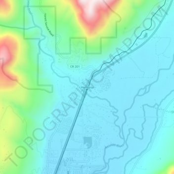
Nombre: Mapa topográfico Hermosa, altitud, relieve.
Lugar: Hermosa, La Plata County, Colorado, United States (37.39528 -107.85534 37.43528 -107.81534)
Altitud media: 2.128 m
Altitud mínima: 2.003 m
Altitud máxima: 2.636 m
Haz una donación
Otros mapas topográficos
Haga clic en un mapa para ver su topografía, su altitud y su relieve.
Durango
United States > Colorado > La Plata County
Durango is set within a striking and diverse topography characterized by its elevation of 6,512 feet above sea level and its position in the Animas River Valley. The city lies at the foothills of the rugged La Plata Mountains to the west and is flanked by the San Juan Mountains to the north and east. This…
Altitud media: 2.162 m
Haz una donación
Durango
United States > Colorado > La Plata County
Durango is located at 37°16′N 107°52′W / 37.267°N 107.867°W / 37.267; -107.867 at an elevation of 6,512 ft (1,988 m). At the 2020 United States Census, the town had a total area of 10,946 acres (44.296 km2) including 1,533 acres (6.203 km2) of water.
Altitud media: 2.162 m
Haz una donación