
Haz una donación
Mapa topográfico Seguin Township
Haga clic en el mapa para ver la altitud.
Haz una donación
Acerca de este mapa
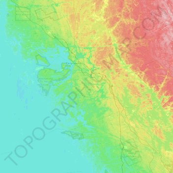
Nombre: Mapa topográfico Seguin Township, altitud, relieve.
Altitud media: 223 m
Altitud mínima: 171 m
Altitud máxima: 374 m
Haz una donación
Otros mapas topográficos
Haga clic en un mapa para ver su topografía, su altitud y su relieve.
Grundy Lake Provincial Park
Canada > Ontario > Parry Sound District > Unorganized Centre Parry Sound
Altitud media: 197 m
Haz una donación
Pickerel River
Canada > Ontario > Parry Sound District > Unorganized Centre Parry Sound
Altitud media: 200 m
Haz una donación
Diamond Lake
Canada > Ontario > Parry Sound District > Seguin Township > Orrville
Altitud media: 273 m
Haz una donación
Lake Bernard
Canada > Ontario > Parry Sound District > Strong Township > Sundridge
Altitud media: 347 m
Harris Lake
Canada > Ontario > Parry Sound District > Unorganized Centre Parry Sound
Altitud media: 209 m
Haz una donación
Ferguson Island
Canada > Ontario > Parry Sound District > Unorganized Centre Parry Sound
Altitud media: 206 m
Haz una donación
Haz una donación
Magnetawan River
Canada > Ontario > Parry Sound District > Unorganized Centre Parry Sound
Altitud media: 198 m
Haz una donación
Killbear Provincial Park
Canada > Ontario > Parry Sound District > Carling Township
Altitud media: 184 m
Cole Lake
Canada > Ontario > Parry Sound District > Unorganized Centre Parry Sound
Altitud media: 216 m
Haz una donación
Haz una donación
Key River
Canada > Ontario > Parry Sound District > Unorganized Centre Parry Sound
Altitud media: 194 m
Culin Lake
Canada > Ontario > Parry Sound District > Unorganized Centre Parry Sound > Arnstein
Altitud media: 230 m
Haz una donación
Bob's Lake
Canada > Ontario > Parry Sound District > Unorganized Centre Parry Sound
Altitud media: 255 m
Spring Lake
Canada > Ontario > Parry Sound District > Unorganized Centre Parry Sound
Altitud media: 317 m
Haz una donación
Haz una donación
Oastler Lake Provincial Park
Canada > Ontario > Parry Sound District > Seguin Township
Altitud media: 218 m
Restoule Lake
Canada > Ontario > Parry Sound District > Unorganized Centre Parry Sound
Altitud media: 245 m
Haz una donación
Key River
Canada > Ontario > Parry Sound District > Unorganized Centre Parry Sound
Altitud media: 193 m
Haz una donación
Haz una donación
Haz una donación
Haz una donación
Haz una donación